 This was my first time on the African Continent, from 12/21/2005 to 1/15/2006. My climbing buddy
Dirk Summers and I decided to travel to East Africa to climb Mount Kilimanjaro and Mount Kenya, Africa's two highest peaks.
This was a very ambitious undertaking, for which we explicitly trained for (check out the Royal Arches
climbing trip, which became a mini-epic). Although I have traveled to quite a few exotic places in Asia, Europe, and
South America before, the wild and beautiful nature of Africa and her diverse, hard-working, friendly people
left a deep impression on me. In some ways Africa is quite a lot behind other parts of the world, but her unique strengths
and challenges are singularly powerful and beyond comparison. To me
this trip to the east African countries of Tanzania and Kenya was one of the most unique experience of my life.
This was my first time on the African Continent, from 12/21/2005 to 1/15/2006. My climbing buddy
Dirk Summers and I decided to travel to East Africa to climb Mount Kilimanjaro and Mount Kenya, Africa's two highest peaks.
This was a very ambitious undertaking, for which we explicitly trained for (check out the Royal Arches
climbing trip, which became a mini-epic). Although I have traveled to quite a few exotic places in Asia, Europe, and
South America before, the wild and beautiful nature of Africa and her diverse, hard-working, friendly people
left a deep impression on me. In some ways Africa is quite a lot behind other parts of the world, but her unique strengths
and challenges are singularly powerful and beyond comparison. To me
this trip to the east African countries of Tanzania and Kenya was one of the most unique experience of my life.
Our detailed plan was to first climb Kilimanjaro (in Tanzania), the highest mountain in Africa at 19340 feet/5895 meters
elevation. Because this is a non-technical climb, we hoped to do this climb first to acclimatize to high altitude. After this,
we will
spend a few days on safari trips to recuperate before climbing Mount Kenya (in Kenya), the second highest mountain in Africa at
17058 feet/5199 meters. Mount Kenya does not have a walk-up route, most trekkers climb the subpeak Point Lenana, about
700 feet/210 meters lower. The easiest route to the highest summit of Mount Kenya requires technical roped climbing
(class 5.7, grade IV)
for nearly 20 pitches, which we probably would not be able to complete in one day. Fortunately there is a nice sturdy hut
on top of the second highest summit of Mount Kenya (Point Nelion), where we can stay overnight before attacking the
highest summit (Point Batian). Mount Kenya is the most challenging and committing climb on this trip,
we planned to be well-acclimatized before doing it. After Mount Kenya, we would have time to rest and relax on the fabled
tropical island Zanzibar (part of Tanzania), in the Indian Ocean. This trip plan worked out despite many obstacles.
After I concluded my trip, Dirk spent another week
exploring Uganda, a neighboring East African country. He visited mountain gorillas in the lush tropical jungles, and
rafted on the upper Nile River.
Arriving in Kenya via Amsterdam
Enroute to east Africa Dirk and I stopped over for a few hours in
Amsterdam, Netherlands in western Europe. It was deep winter in Amsterdam, daylight seemed non-existent
while we explored the medieval architecture of the old city, the famous coffee houses, and Christmas festivities
in the dusky, dreamy light. This is the ultimate hippie city, long cosmopolitan and filled with eclectic
energies. Curiously, the coat of arms of the city since medieval times is "XXX": three St. Andrew's crosses.
On the morning of December 21, 2005, we arrived in Nairobi, the capital of Kenya. A few days before I contacted
a hotel in Nairobi
by email and they promised to send someone to pick us up for a good price. After spending 40 minutes looking for our ride
who didn't show up,
we ended up with a taxi driver who seemed knowledgeable and would take us to the city for a lower fee. His name is Dennis,
a tall, easy-going man from the Kamba tribe.
We went with Dennis and he hooked us up with a travel agent in the city that would arrange for our excursion
trips to Mount Kilimanjaro and the big game parks in Tanzania. Our tour operator in Tanzania would be Zara International,
a company with a good reputation according to our research. For lack of cash (Dirk had problems withdrawing cash from
the local Barclay bank ATMs) we didn't book our Mount Kenya trip which was to happen later. Nairobi was hot, the two of us
stuck out like a sore thumb, but we weren't hassled as much as I would have expected even when we were unaccompanied by locals.
Dirk decided to cut off his long blond hair, so Dennis took us to a hair salon. The cost was a
bit high but according to Dirk the head massage was really good.
Climbing Mount Kilimanjaro
My first impression of African landscape was the dusty, semi-arid plains surrounding Nairobi. Despite it being dry season,
it looked rather
improbable that this dry land supports such a large population. Later on we learned that Kenya was experiencing
a serious drought which was killing people (notably the Massai) and their livestock. As we rode the bus south across the
border to Tanzania, the scenery was that of long stretches of semi-arid scrubland with islands of lushness,
notably near Arusha, where 4566-meter-high Mount Meru is located. When we got close to the little town of Moshi at the
base of Mount Kilimanjaro,
this huge volcano's majestic shape enveloped the horizon as if hugging the earth from above, its body looked incredibly
broad once we discern its faint outline in the
hazy warm air. We settled into the beautiful Springland Hotel operated by our tour company. It's very comfortably furnished
and run like a tropical resort. Outside the gates of the plush hotel however, is a slice of normal rural Africa with
trash heaps, (free-range) chicken running around, and vultures hovering. Every morning the prayer calls of the mosque
in town woke us up, something we hadn't experienced before. Dirk found it rather uncouth that
German tourists in the hotel walked around in their briefs in public. This was amusing to me since Dirk has German ancestry
and speaks fluent German.
I didn't respond well to the hot sweaty bus ride from Nairobi to Moshi; I came down with a cold soon after arriving.
It immediately cast
doubt on our Kilimanjaro climbing plans, original scheduled for 6 days starting on December 23rd. I had heard about the
dangers of often fatal pulmonary or cerebral edema when people go to high altitudes with a cold. We decided to ask for
a delay from our hiking guide, Joel. Joel is a handsome young man from the Arusha tribe, around 29 years old, bald headed like
most guys over here. His English is so-so, and he is a man of few words, but he exudes an air of calm control. He said fine,
we can do it in 5 days via the Umbwe route. This meant no change in the end date of our climb, so we wouldn't have to pay
extra for this change. Although originally Dirk had ambitions to climb one of Kilimanjaro's glaciers, it would have been
logistically very difficult and I didn't feel I had the skills to do it safely. We ended up choosing the Umbwe route,
it is the shortest and most direct route to the summit, and also the steepest, so it sees fewer climbers than other routes.
From the Umbwe route we would be attacking the summit via the Western
Breach, a class 3 path. The Western Breach is more difficult than other routes to the summit, but we felt we're in better
shape than most tourists. By taking this approach we would save 2-3 days from the regular tourist itinerary.
A week after our successful climb we heard on the news that
3 American climbers were killed by
falling rocks on the Western Breach. We count ourselves very lucky that we got through here safely.
Exploring souvenir shops, restaurants, dance clubs and buying some medicine took most of our free day in Moshi,
a fun and relaxing experience. We met many fellow tourists from different countries.
By December 24th, we had to start the trip even though I didn't feel 100 percent. Joel brought in
his assistant guide John, a cook, and 5 porters, so a total of 8 people would help the two of us make it to the summit.
Most of the porters are from the Chagga tribe native to the Kilimanjaro region.
I rented hiking poles before taking off in the jeep heading for the Umbwe trailhead. The jeep navigated muddy dirt roads up
into the increasingly lush foothills of Mount Kilimanjaro with many banana fields. After an hour we arrived at the park gate,
completed paperwork while our porters quickly sorted the provisions. To our surprise they didn't have the type of
lightweight camp stoves we use for backpacking in the West, they would be carrying a heavy household gas stove up the
mountain with us. At the park entrance there were a number of climbing parties each with numerous porters, and much gear
were strewn about.
The first day we were going to gain about 1000 meters elevation, from about 1800 to 2800 meters (5900-9200 feet).
We started out on a wide dirt road in the tropical forest surrounded by tall tree ferns, and the weather was quite warm.
Our guides Joel and John walked with Dirk and myself while the porters soon barrelled ahead to make camp. After the
initial flat stretch I started to fall behind, and John stayed behind with me. In the late afternoon it rained for
about 2 hours,
so I put on my rain-proof parka. The weather wasn't cold, the ground was very muddy and steep, and our pace was fast.
Around 6 PM we reached the Umbwe Caves camp site, sheltered by huge boulders. There were about 3 other parties
already there, and Dirk was relaxing with our porters. Most of the porters are physically small but they are very fit.
We saw porters from other parties practically running up and down the trails bare-foot while carrying huge bags
on their heads. Once at camp they started a festive party, there was non-stop conversation and
portable radios playing music and news, all in Swahili, the lingua franca of east Africa. We were served
meat stew and potatoes with vegetables, then we enjoyed hot tea. The porters slept in large communal tents while the
two of us slept in Dirk's backpacking tent. The first night was quite comfortable. There was
an enclosed squat bathroom behind the camp site, its floor was leaning quite a bit so it was rather uncomfortable to
use it. We were advised about the presence of
leopards at this elevation, but with this many people at the camp site the risk of attack was almost nil.
The second day we climbed out of the forest and into moorlands covered by shrubby heath about a man's height. The
signature giant groundsels (a giant herbacious plant only found on high African mountains) with their huge rosette formations
started to appear. As we climbed up a steep ridge we were
greeted with our first sight of Kibo, the main volcanic cone and the highest summit of Mount Kilimanjaro. The world's
largest single mountain mass lives up to its reputation, showing its long smoothly ascending ridges
reaching over a great distance to the ice-laced summit. Jagged Mawenzi,
the second highest volcanic cone was also visible behind the long ridge on the horizon. The ridge we're following
upward was the Umbwe ridge, sometimes it narrows to only a few feet wide, dropping off hundreds of feet on each side,
although it wasn't that scary due to the dense shrub cover. As the afternoon progressed the cloud cover started to envelope
the entire mountain, and it rained again, this time much colder in an alpine tundra setting. I wanted to keep up
with the others but fell behind again, while John followed me, offering to carry my day pack. I let him, and finally
made it to the Barranco camp, elevation 3900 meters/12,800 feet.
The barranco camp had lots of climbing parties staying because it's on the southern summit circuit path.
It's located beside a huge gash in Kilimanjaro's southwest face, where an ancient landslide created
the deep Barranco Valley. From here we looked up directly to Kibo's southwestern face, called the Breach Wall. This is
the most vertical face of Kibo, where a number of glaciers hang on the cliff face and the recesses. To the west of the
Breach Wall is the gap in the crater rim called the Western Breach, from where we would ascend to the crater and then to
the summit. The shifting clouds wafted in and out of the space between us and Kibo, making the icy cliffs of the
Breach Wall seem closer and more imposing. The astounding scale of this huge mountain was
overpowering and the icy air menacing.
The Barranco camp has a small round hut with a radio antenna, very useful during rescue operations by the Kilimanjaro
National Park. The porters mostly huddled inside the hut because of the cold, and we snuck into our sleeping bags long before
dinner was served. I was coughing a lot and losing apetite, Dirk seemed to have caught the cold from me as well.
I woke up in the middle of the night with a pounding headache, and when I got up to relieve myself I was stumbling. My
distance vision seemed affected when I looked at the frost-covered tundra under the light of my headlamp in order to take
each step. I felt like I was on the moon, and I had never felt a headache like this. In my mind I was in an alien,
inhospitable place, and I shouldn't be here. I decided to take my diamox pills, the medicine I prepared for altitude
sickness. In an hour or so I started to feel better, while Dirk woke up with severe coughing. Later on he decided to
take the medicine also, and we finally were able to sleep some.
In the morning after having hot tea and breakfast with eggs and muffins, we started going higher up toward the Arrow Glacier
camp, elevation 4868 meters/15,970 feet. Because we're doing the climb in 5 days instead of 6, we would skip the Lava
Tower camp, normally used to improve acclimatization. This meant another day of nearly 1000 meters ascent. It was
another difficult day, I was trudging up slowly in the thin air, while Dirk fell behind for the first time.
Apparently I was on the recovery of my cold while he was getting sicker. Joel accompanied me this time, and carried
my day pack later in the day. We were enveloped in the mist most of day and made it to the frigid camp site still with
much day light. I think I hike better when not sweating, and this coldness helped. After arriving at camp in good
time Dirk decided to explore the lava towers around the campsite, and the remnants of the fast-disappearing Arrow Glacier.
He's excited that tomorrow would be summit day as we discussed climbing plans with Joel. The porters would not climb to
the summit with us, they would pack our provisions to the next camp site on our descent route via the south summit circuit
path. Only our guides Joel and John would make sure we make it to the summit. As evening approached snow began to fall, and it
fell continuously into the night. Originally Joel's plan was to start hiking toward the summit around midnight or so,
which is the usual schedule for most climbing parties. This is because the summit day has the largest elevation gain
and would be the most challenging day due to the highest altitude, so most parties leave extra time just in case.
We would be climbing from 4868 meters to
5895 meters, a total of 1027 meters (3370 feet). Because of the snow fall however, Joel was concerned that the route would
be unsafe to climb at night, so he decided a later start. We planned to get up at 4 AM and start hiking at 5 AM.
Luckily for us the snow fall stopped a little after midnight.
Sleep was short and I got up in good spirits for the long hike ahead. Joel knew that I hike slower so he told me to
start earlier. Before Dirk was ready, Joel and I started to hike
up the Western Breach in the darkness, walking on a thin layer of powdery snow. As the day broke the climb got steeper
and steeper, becoming class 3 in places. The loose piles of huge blocks surrounding us were ominus since they could roll
down at us any minute. Extremely exhausted and lacking oxygen, I frequently rested, but Joel kept hollering at me to
keep going. A bit later he started to carry my day pack and I felt a little more energy on the climb. I was able to
barely keep up with Joel, while John was leading Dirk far below us. Dirk insisted on carrying his full gear with an
ice axe, and had serious trouble keeping up because of his cold. When Joel and I reached the crater rim at 18000 feet,
we waited for
the other two as the next stretch was the final hill to the summit. A lot of groups camp on the crater rim to break up
the long ascent as well as to see the sun rise over Africa's highest volcano. Not having time for that, we regrouped
for a short while at the rim, then pressed on at the urging of Joel who was afraid of more snowfall later in the day. There was
a short flat stretch where we took photos of the Furtwangler Glacier, a spectacular sheet of ice a hundred feet thick
lying lat on the crater rim. Just as we worked our way above the crater rim up the final hill, we were enveloped by wind
and hail. Visibility was getting poorer. I was at the end of my strength, hoping we didn't need
to be rescued as the next camp would be a long way away. I could only keep going at the prodding of Joel, who was always
confident we could make it. Once we reached the ridge top in the windy and misty weather, I followed Joel through the final
flats to Uhuru peak, the top of Africa, the summit of Kibo, the highest point of Mount Kilimanjaro. Joel
and I took pictures as we waited for the other two, who arrived about 20 minutes later. Dirk was
emotionally stressed; his sickness made the summit day
even more challenging. After a few hero shots with the wooden posts and plaques marking the summit, we were led by Joel to come down
another route, the Mweka. This is a usual descent route because it's fast and direct.
We quickly lost much elevation as we trudged down steep steps in the volcanic sand, similar to a long scree slog which
we're very used to in California's mountains. Joel wanted to make it to Mweka
Camp (3100 meters/10200 feet) that day, that would mean descending 9140 feet in one day. And that's after doing the most
challenging ascent earlier in the same day! We protested and finally agreed on setting our goal at
the Millenium camp, elevation 3837 meters/12590 feet. The hail turned to rain as we slogged past
Barafu hut, situated beside large rocky slabs. After more fast slogging we arrived at Millenium camp, when the sun hadn't
set yet. It was a great relief to be back in a fairly warm, vegetated place with people, and our porters were happy that
the trip would be over in just another day, when they could go home. The atmosphere was festive for the porters, but all
I could think of was to slow down and rest. This camp was even equipped with a decent toilet.
Through the heath bushes we had glimpses of the perfect conical-shaped Mount
Meru in the distance. Looming above was the icy Kibo, now so beautiful although harsh and unforgiving just hours
ago. We took a shot with all the porters (except the one that served us dinner every day, didn't know where he was) and
Kibo in the background. What an unforgettable experience!
The last day was downhill all the way in warm sunshine, we noticed the flowering trees and numerous wild flowers,
such as the Kilimanjaro impatiens and the gladiolus. We made the whole descent to Mweka park gate (1676 meter/5500 feet
elevation) in a little over 2 hours, dropping nearly 2200 meters! The increased level of oxygen in the air was very appreciated.
At the park gate we completed the paperwork to certify that we had climbed Africa's highest mountain. At the village down
from the park we took a break from the jeep ride, tasted banana beer and looked over some handicrafts.
A little later we were back in Moshi in the plush
Springland Hotel for more relaxation. The next day Joel came by to receive tips for his porters and delivered our official
certificates from the Kilimanjaro National Park of Tanzania. It was great to see him again and Dirk wanted to tell him
about mountaineering in the States. They promised to keep in touch. I felt extremely thankful for Joel, John, and our
porters for helping us so much during the climb. There was no way that I could have made it on my own, and physically
this was the most challenging climb I had ever accomplished.
Safari trip to the famous Serengeti
During our rest day in Moshi we moved to the Buffalo Hotel and hung out with a trio of young Americans
(2 girls and a guy in their mid-20's) from the East Coast. One of the girls was going to do a medical internship
for 3 months in a little town a few hours south of Moshi. In addition to souvenir shopping we even went to a dance
club. The next morning when the promised ride to our safari trip didn't show up, we found out our tour operator
had forgotten about us. So they set up a trip just for us, and we were able to leave early in the afternoon.
This turned out
quite nice for us: with a minibus, a driver, and a cook, just for the two of us for 4 days,
no sharing with other tourists.
Our driver was Al-Bakari, a shrewd guy who knew everything. His dry sense of humor was quite entertaining during the
long drives.
We camped at Mto Wa Mbu ("Mosquito River" in Swahili) for the first night. We were able to visit
nearby Lake Manyara National Park that evening as well as next morning. The game
viewing was absolutely incredible. I had never experienced anything like this in my life; the large, beautiful,
compelling animals
and the endless open vistas of Africa made a magical, indelible impression in my mind. This is no wildlife game park
as we knew it, it's the primordial paradise. In the background of all this wildlife the majestic mountainous escarpment
forming the Great Rift Valley marched in a straight line to the horizon. The next day we drove further west on a modern
Japanese-built highway toward Ngorongoro Crater, a UNESCO World Heritage Site. On the way to the the Crater
Highlands Massai herders could frequently be seen
walking in their traditional red or purple capes. The largest
intact volcanic crater in the world (12 miles wide and 2000 feet deep), the Ngorongoro epitomizes nature at its most
compelling. Bones of earliest humans have been found at nearby Olduvai Gorge, and the nearby active volcano
Ol Doinyo Lengai
is the "Mountain of God" for the Massai. I suggested driving a bit off the beaten track to see this special mountain,
but the long, rough trip on dirt tracks would have taken more time and gas than we had. The game viewing in Ngorongoro
was a bit crowded: many safari vehicles vied for the best view points, but none of the big animals showed any concern
for us. Lionesses even used the line of vehicles as cover to stalk their prey. This evening we camped on the rim of
the crater in a magical setting overlooking the vast recesses below. The camp guards here carried rifles to guard against
large predators. Dirk was excited to see an elephant roaming the vicinity, and during our drive to the campground
we passed numerous giraffes.
The third day we drove to Serengeti National Park, the most famous African game park frequently shown on PBS
back home. The long
drive was over a wide dirt road in a completely featureless plain with low shrubs and dry, red dirt. In the distant
horizons
hundreds of miles away were chains of low ranges. The wide open views were mind-boggling, occasionally groups of animals
could be seen traveling in the distance.
As we got closer to the heart of the park the landscape changed to the stereotypical African savannah with occasional
acacia trees grazed clean below the height of average giraffes. There were also occasional thickets, but dried grass was
the predominant vegetation. Here our campground was well-equipped with dining pavilions surrounded by metal wire
fences much like fishing nets, designed to prevent attack by predators. I tried to walk a couple hundred feet from the
campground, but several passing
drivers who saw me made sure to let me know that walking around was not allowed for my own safety.
This was also the night of New Year's eve, Dirk specifically bought a bottle of
champagne at the park store. As night darkened there were a few other tourist parties in the dining pavilion, one
was a big Japanese party. We met a middle aged man from eastern Germany from another party who stayed on after dinner.
Since Dirk also speaks German, three of us hung out that evening
and shared the champagne among us. It was just great to have our own New Years celebration here deep in the African
wilderness. The next morning
Bakari took us around the vast park for more game viewing, here the most memorable for me was a large herd of elephants
traveling in unison. I was impressed by how fast they walked and the powerful rumble of these majestic animals.
Over these four days I had pretty much seen every species I've heard of in my childhood. To be able to see their full
glory in close range and to be compelled by their power and beauty was just fantastic.
Technical climbing on Mount Kenya
Our Safari trip came to a close sadly as Bakari dropped us in Arusha to meet another bus heading back to
Nairobi, Kenya. Arusha is the hub of the northern Tanzanian safari circuit with much modern tourist facilities.
We had a meal
in a very comfortable and modern-looking hotel but when the bill came we were surprised. Apparently their prices were
designed to mislead. Since Dirk and I didn't have enough cash on us,
after protesting the lady managing the place accepted what we had. Once arrived in Nairobi, we decided to stay in a
different hotel: one with a nice
cafe at the bottom floor. While having dinner we met numerous backpackers, one doing an overland trip from the
southern to the northern tip of Africa (Capetown to Cairo). Quite incredible. Hearing that we planned to climb Mount
Kenya, our hotelier immediately called up a trekking operator. A young, smart fellow named Josiah Waithaka from a
company called Mountain Madness
came to meet us the same evening. He appeared to have done technical climbing himself,
unlike the more business-like travel agent lady we booked our Kilimanjaro trip with. Dirk and I were impressed,
and the name Mountain
Madness rang a bell (it's actually a well-known guiding company based in the USA, but we found out later that
Josiah's company was unrelated to it). So we concluded a
deal at a reasonable price with him, and he promised us to head for Mount
Kenya the next day.
We spent 7 days on Mount Kenya, including the first day driving from Nairobi to Chogoria, a little country town on
the east side of the mountain. We started pretty late since Josiah took some time to put together the car and
some provisions. Peter, a robust, charming fellow came to join us. He would be our trekking guide from here on.
As we traveled pass the highlands of central Kenya there were much lush forests, banana, tea and coffee plantations,
a stark contrast with the arid Tanzanian landscape we'd been traveling through in the last weeks. In the colonial days
English farmers coveted this fertile land; even now there are
siginifant numbers of white-owned farms around here on land originally taken from local
Kikuyu people. At Chogoria we met our 4 porters: John, Robert, Wilson, and Paul, 3 of which are Kikuyu and one is Meru,
found on the east side of Mount Kenya.
The morning of the second day, our trekking party laden with groceries and raw meat rode a jeep through the lush forests
to the park gate. The deep ruts in the dirt track we
were riding on got even deeper the further we went, eventually to about one and a half foot deep. Our jeep driver
made a few
moves that made Dirk nervous, then the jeep got stuck. It took a while for our guys to get it going again.
Unlike the low-altitude trailheads on Kilimanjaro, the Chogoria park gate for Mount Kenya was at 9840 feet (3000 m)
elevation, the landscape here was alpine moorland. We'd already passed through several eco-systems, including the
beautiful bamboo forest belt.
Two buffalo skulls decorate the park gate, along with a sign warning of large animals. Then an elephant appeared,
attracting
attention from hiking parties. We started hiking around noon time on a hot, shadeless trail. The afternoon was spent
hiking along the rim of a majestic
U-shaped valley, among grassy slopes and low shrubs. This is Gorges Valley, formed by prehistoric glaciers. In the middle
of the valley in the distance we saw a dainty high waterfall formed by a big elevation change of the valley bottom.
The air was cool with light mists
swirling around us, it's ideal hiking weather. The scenery was wonderful and magical, somewhat reminds me of the
Lord of the Rings movies. There were many ups and downs during the day's hiking; later in the day I became
sweaty and tired, lagging behind others. Peter decided to carry my pack for the last 2 miles, still it was one of my
most painful hiking days (over 5000 feet elevation gain and over 10 km). Finally I reached our camp site
beside a clear alpine tarn
called Mintos tarn (14100 feet elevation / 4298 m).
Surrounding the tarn are rugged volcanic crags, among which giant groundsel and lobelia plants unique to high mountains
of East Africa proliferate. As the sun sets it became freezing cold and the giant plants helped create an eerie
other-worldly atmosphere.
The next day our hike was much shorter as we trudged our way to Austrian Hut (15715 feet / 4790 m), the main basecamp
for the summits of Mount Kenya. Enroute we traversed lots of scree and even passed an airplane wreckage. We arrived at
camp fairly
early, so I explored the sturdy building with several rooms where the porters from many parties were staying. The
building sits on solid rock, but around it many solid ice patches
formed from washwater. Both sides of the building has dramatic views: looking west one sees Mount Kenya's jagged
central
summits (Nelion, Batian, Point John, Point Lenana, Point Thompson) shrouded in swirling mists, majestically presiding
over Lewis glacier; looking east one sees Hobbley Valley dropping down to the horizon bounded by two long ridges of
peaks and a sea of clouds. Despite the copious beauty, I was occupied by worry: my stomach was
not feeling good after several days at altitude, and I was coughing a lot. With a very long
technical route ahead I needed to be as fit as I could be. The freezing cold and the chilling mists bothered me.
We retired
to the hut, where we made a decision to scout the beginning of our route the next day, and do the actual climb the day
after. This meant we would have a rest day to adjust to the altitude, and also we would avoid wasting time looking for
the route on the day of our climb.
The next day we had a late start, and chatted with a pair of mountaineers from Colorado over breakfast.
The guy and girl had made the Mount Kenya summit in a
single day. They were obviously very good climbers, the guy was a professional mountain guide.
We then navigated to the start
of the technical climbing route on the east face of Nelion, which took two hours. It required crossing the Lewis glacier,
which was a piece of cake with or without crampons, then ascending about 800 feet of talus/scree. Along the way
I discovered a dessicated carcass of a leopard, very unusual for this high altitude.
Apparently it couldn't survive this cold country. There was another party there also scouting the route, and a
Kenyan guide waiting. Dirk gave him instructions on rope techniques while waiting for the other party to move further.
Then Dirk attempted parts of
the first two technical climbing pitches without roping up, it looked fairly easy. We returned to camp for lunch,
then in the
afternoon Dirk went for the summit of Point Lenana (16355 feet / 4985 m elevation) with our guide Peter. I declined
to go because I was still not feeling well. I vomited food after having a meal, and felt emotionally overwhelmed.
I stayed in the
hut to rest up, or walked around camp to take pictures when the sun was about to set.
The next morning we got up at 4 am, our porter Wilson cooked pancake for us and saw us leaving camp after the
quick breakfast. Hiking up the
approach route was not easy because of the 800 feet elevation gain and our heavy packs, including sleeping bags, food
and water for two days, ice axe, and crampons. As day broke we started out on the technical
route Dirk leading each pitch and I following. There was a South African party of 2
who passed us before we got on the 1st pitch, then soon disappeared from sight.
The mists started to surround us around 10 am, when we were close to the east ridge of Nelion. There was
a stretch that Dirk thought was easy, but the heavy pack on my back made it much harder to balance on
easy but exposed rock, so I panicked. I got Dirk to give me a belay there for a bit of peace of mind. Route-finding
was never easy, after
studying our guidebooks carefully we were able to find the correct route throughout the day. We moved on and on in
the cool mist,
except for one time my butt got wet from sitting on a belay ledge with snow, in general it was not as cold as I had
anticipated. Of course I was using full protection including a heavy mask, parka,
and gloves. By the time we reached Point Nelion at 17021 feet / 5188 m elevation, it was about 5:30 pm and the
South African guys (Matt and Roger) were already there. Amazingly they had already climbed Point Batian from here and
returned. It was a great relief for me to
be done for the day, and even more so after seeing that the sturdy 6' x 6' x 4' metal box called "Howell's hut" was
indeed a feasible shelter,
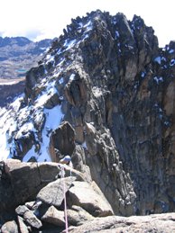
securely bolted to the summit rocks. The summit of Nelion was small, only 20-30 feet across with precipices on three sides.
From here we saw Point Batian, the true summit of Mount Kenya, only a few
hundred feet away - a brooding giant with near vertical rocky faces. We were even able to see Mount Kilimanjaro in the
distant horizon above the clouds, over 200 miles away. Majestic views surrounded us in every direction, with
swirling mists floating around
the rocky spires and Lewis glacier quite a ways below us. We had good conversation with Matt and Roger
while doing the chores for the evening. I was glad to hear that Roger works in the urban planning field in Cape
Town!
Overnight it was surprisingly warm in the box with four guys crammed inside. The box was well insulated with foam pads,
and my thermal blanket and sleeping bag certainly did their jobs. Matt decided to sleep outside at some point
in the night, probably annoyed by my and Dirk's constant coughing, or maybe it was simply too crowded.
At one point Roger
told me I was snoring, which woke me up. This became a joke Dirk kept telling others about me later on. I went outside
to use the toilet and found it was not as cold as I expected. The air was amazingly still and no mist whatsoever.
The morning was sunny and glorious. No mists, only full view of Batian and the landscape far below us, free of clouds.
The South African chaps went down, while we headed over towards Batian. This was the most challenging, almost harrowing
part of the climb. We needed to descend 300 feet down to a gap called Gate of the Mists, then ascend the east ridge of
Point Batian,
a mere 37 feet higher than Nelion. Our descent from Nelion was at first manageable solo down climbing, then we rappelled
down a buttress to the gap. We left the rappel rope there for later use.
The gap was a thin knife edge surrounded by loose snow a few inches thick, offering no tracting to the foot.
We needed to tread carefully as these snowfields
dropped off on both sides precipitously. Once we crossed the gap, I accidentally dropped
a walkie-talkie down there (while taking a photo of the dramatic landscape), never to be retrieved. We stashed ice axes
at the gap to be retrieved on our way back. On the side of Batian,
after ascending a few well-protected snow steps, we were on solid rock which was much preferred. Dirk set up and lead
three pitches of face climbing on beautifully textured rock of a golden color, harder than granite it seems. In the
last pitch
it was easy enough we just unroped and scrambled to the summit. It was a great feeling to be at the top of Africa's
second highest peak finally, after so much preparation and so much effort. However, we needed to get back safely, and we
needed all the time we could have. So we stayed on the summit for less than 10 minutes before starting to head back.
Rappelling down
the three rock pitches were easy except for the last pitch, where Dirk rappelled to the wrong (left) side of the gap.
That side was
much more treacherous with steep snow and exposure. Not knowing this, I waited for Dirk for almost half an hour and
did not hear from him respond after repeated shouts. Finally I heard he's getting
himself out of the difficult terrain. He had to unrope himself in order to downclimb, which I couldn't imagine in this
extremely exposed terrain. I retrieved my ice axe at the Gate of the Mists, at this time one side of the gap was
already shrouded in
the famous mists. Once Dirk made it safely to the gap, he started climbing up a steep snow pitch with some
well-formed foot steps by previous climbers. About 10-20 feet away is the precipice. I couldn't follow this, it's just
too much exposure without
protection. I waited till Dirk made it up the rocky buttress so he could give me a belay. I roped up, then gingerly
traced
those footsteps in loose snow. Without protection here, one slip you're gone, no self-arrest is feasible with
an ice axe. Even
with the rope, if I slipped on the snow the rope would have taken me swinging to another side, maybe landing in even
more
treacherous terrain. After I climbed up this most appalling section, Dirk decided to continue up solo. I wanted a belay
but he said it would take too long, he encouraged me to climb this section solo too. I decided to give my best shot.
We were still in steep
snow, sometimes just 10 feet from the edge of precipice; the only way to ensure some safety was to hold onto the rocks
that protrude from the snow here and there.
This turned out to be doable, so I did this section with the utmost care. There was no room for error at all, it was
extremely
nerve-wracking. After about 10 minutes, we were in much easier and safer terrain with much less snow. I could handle
that more
confidently. We made it back to Nelion and the metal box shortly after. This trip to Batian and back took us 4 hours.
Having done the toughest part of our climb, we rested for an hour. It was about 1 pm, we needed to head down.
We started looking for rappell anchors according to descriptions in our guidebook. The first few were relatively easy,
except one Dirk missed I was able to find when I rappelled second. As we reached the east ridge of Nelion, we just
couldn't find the next anchor.
We had to create a makeshift anchor, seeing that others had done this before by the gear they left here. Then we
were able to find a few more anchors, but then we were stuck again. In the second-to-last rappell, the landing ledge
was on the climber's left side, but I couldn't make myself go that way because of my heavy pack. I was exacerbated.
I struggled with the weight on my back and the rappell rope in vain. Dirk was able to grab me after encouraging me to
swing back and forth, eventually helping me land safely.
Having lousy luck finding the next anchors we decided to make another makeshift anchor since the day was getting late.
It was a big relief when
we finally reached firm ground. We survived! We made it! The sun was setting now. Extremely exhausted, I hiked
down slowly, eventually crossing the Lewis glacier when it was dark enough to need headlamps. At the other side of the
glacier,
we saw Peter, Paul, and Wilson waiting. They had come to meet us! It was such a relief to see them. Paul eventually
picked up my pack, which helped me walk the last few hundred feet to camp. Peter told us they were very worried about us,
but later in the day they were able to see that we were descending the mountain but missed several rappell anchors!
Our porters greeted us with hot tea, and Robert excitedly told us about watching us descending the whole afternoon.
It
was just great, people in the whole hut discussing about our missed rappell anchors! The hardest part of the trip was
finally over, Dirk was elated that everything went successfully
according to plan. The next day we hiked out toward Sirimon gate on the north side of Mount Kenya. After descending
tons of elevation and seeing countless giant groundsels and lobelias, we took a break at Shipton's camp in Mackinder
Valley. Here the
north side view of the central massif was superb, with many small glaciers visible surrounding Batian and Nelion.
This is a very comfortable facility and we met more tourists. After a short rest we proceeded further on an endless
landscape of shrubs and grasses, among which
roamed a plump pheasant-like bird called francolin. After many many miles of downhill, it started to rain and we
hurriedly made
it to the next camp - Old Moses camp, elevation 11155 feet / 3400 m. This was quite a comfortable camp with a nice
series of
buildings, although we camped outside in the crisp clear air. The lower elevation was a great welcome, as I was finally
rid of the stomach upsets that plagued me everyday at Austrian Hut. The last day we hiked down for just 2 hours to reach
Sirimon gate (elevation 2440 m / 8005 feet). Tons of wild flowers appeared along the trail, along with wonderful vistas
of the lower flanks of the mountain and lush forests.
From park gate we went to the town of Nanyuki, where we enjoyed a beer and the local barbecue, called "Nyama-choma"
(I think I got a case of the runs from it). The
facilities were very basic but the people cheerful. We tipped our guide and porters generously, then parted our ways
before heading to Nairobi with only Peter. As we passed the town of
Karatina Peter told us this was his hometown. Finally we were back in Nairobi in the same hotel as before, enjoying a
bath and relaxation. The next day we made arrangements to fly to Zanzibar for the last 6 days of my stay in Africa.
Before leaving Nairobi we made it to the famous restaurant "Carnivore" and ate all kinds of game meat buffet style.
It didn't take long for us to become extremely full.
Tropical Island Zanzibar
Zanzibar, part of Tanzania ("Tanzania" is a composite name created from Tangenika and Zanzibar),
is the heart of Swahili culture, one of the most historic places in this part of the world.
It has a mixture
of African, Middle Eastern, and Indian cultures, and most people here are muslim. The old town of Zanzibar, also called Stone Town, is a relaxing place by the
Indian Ocean,
filled with exotic scents and sights among the labyrinthine alleyways much like a typical Arab town. The tourist
facilities here are quite a bit more comfortable than in mainland East Africa we've
been to, even Nairobi. It was high summer in this part of Africa south of the Equator, days on Zanzibar were pretty hot.
We took a boat tour of the sandy islands around the port. It was my first snorkeling trip and it was
a wonderful experience. The turquoise waters and the clean white coral sands were incredible, as were the colorful
exotic
shells we found. The coral sands were very prickly to the foot however, and I also stepped into some sea urchins, ouch!
Besides,
I got severely sun-burned during just 1 hour or so of snorkeling, which took more than four weeks to completely
recover. During the boat trip we also visited a sactuary for giant tortoises from the Seychelles,
who were surprisingly agile despite their giant size. These are the world's largest land tortoises. Dirk almost got run
over by a 600 pounder going for the cabbage in his hand.
The Indian-Zanzibari owner of the waterfront Indian restaurant where we booked our boat trip
is quite a character, full of personality. His name is Joshi, and he related to us a lot of local political anecdotes.
Regarding the culinary scene, we visited the night markets on the waterfront where grilled seafoods were served
(this gave me stomach ache, unfortunately); Dirk was amused to
find Chinese restaurants where pork was not on the menu. We also chatted with a young local fisherman at the night
market, he was easy-going and fun to talk to. While we browsed the souvenir boutiques along the alleyways,
a sykes monkey stringed to the fence of a church caught our attention. When I tried to pet it, it snatched money out of my
pocket
with lightning speed! However, I was able to grab my money from its grip since it's tied to the fence and
couldn't get away.
Another night we relaxed in Freddie Mercury's bar, named after the late British rock star born in Zanzibar. The last
two days on Zanzibar we spent on the east coast of the island, at a luxury resort in Jambiani. Because it was low
season, we had the
whole beach resort to ourselves. It was very relaxing by the swaying palms gazing out to the turquoise Indian
Ocean. In the evening we went to a dance party on the beach and mingled with local young people.
All in all, our trip to exotic and fabled Zanzibar was truly memorable, fun, and relaxing. Our Africa trip
was both a major accomplishment, and an incredible growing experience.