 This was my first time in Brazil, from 6/29 to 7/12, 2001. Brazil is one of the world's largest and
ecologically richest countries, has the world's largest river, the Amazon, the majority of the world's remaining
tropical rain forests, and probably the longest Atlantic coastline. Although I did not go as far as the Amazon
on this trip, I enjoyed spectacular hiking in eastern Brazil in two scenic areas relatively close to developed,
historic cities: the Chapada Diamantina in Bahia state in northeast Brazil, and the coastal mountains of Rio de
Janeiro, in southeast Brazil.
This was my first time in Brazil, from 6/29 to 7/12, 2001. Brazil is one of the world's largest and
ecologically richest countries, has the world's largest river, the Amazon, the majority of the world's remaining
tropical rain forests, and probably the longest Atlantic coastline. Although I did not go as far as the Amazon
on this trip, I enjoyed spectacular hiking in eastern Brazil in two scenic areas relatively close to developed,
historic cities: the Chapada Diamantina in Bahia state in northeast Brazil, and the coastal mountains of Rio de
Janeiro, in southeast Brazil.
Chapada Diamantina
Chapada Diamantina is a national park. Its name means "Diamond Plateau". It was the site of diamond
mining in the 19th century. Located in central Bahia state, about 6 hours by bus from the colonial city of Salvador-da-Bahia,
the state capital and colonial capital of Brazil, Chapada Diamantina is a serene, sparsely populated region dominated
by semi-arid scrub in the lowlands and tropical forest in the highlands. It belongs to Sincora Range, with elevation
up to about 2200 metres (7200 feet) culminating in the highest peaks of northeast Brazil.
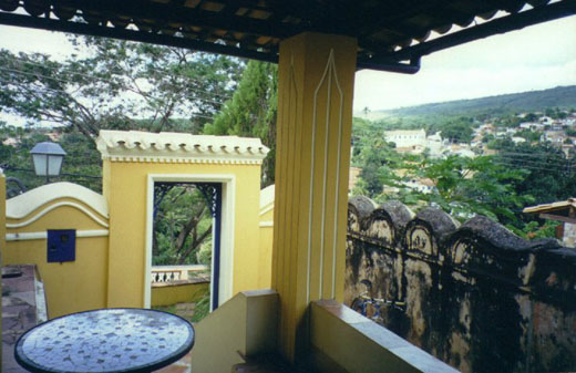
On early morning of June 30th, my friends Fernando and Valdeck from Salvador-da-Bahia and myself took the bus
to Lençois, the hub of the Chapada Diamantina. For the remainder of the day, we found a elegant colonial
mansion to stay, wandered the sloping cobblestone streets lined with mansions surrounded by stone walls, luxuriant
tropical trees and flowering bromeliads. After dinner, I walked to town towards the sounds of bands and a country
singer performing in the several squares.
The next day at the suggestion of our guesthouse owner, we hired a local guide to drive us to the nearby attractions.
First we made the short hike along the Mucugezinho river to Poço do Diablo (Devil's Pool), a large green
pool beneath a 100' tumbling water fall. There were people rapelling down a rope into the pool from the top of
cliffs. We turned back after taking a group photo there. At the roadside there was a hut with carvings of local
shalestones for sale (and a man doing the carving). The shale contains different layers of white and beige, so
the carver can reveal different tones by the depth of carving.
Next we drove to Pratinha (Little Silver Creek), a large pool with connection to an underground river through
a cave. There is a scuba diving outfit here. We hiked down to the pool and saw millions of small fish swimming
in the cave. We enjoyed swimming in the warm pool and sunning on the sand around it. There was also a rapelling
outfit there dropping people from the top of the cliff.
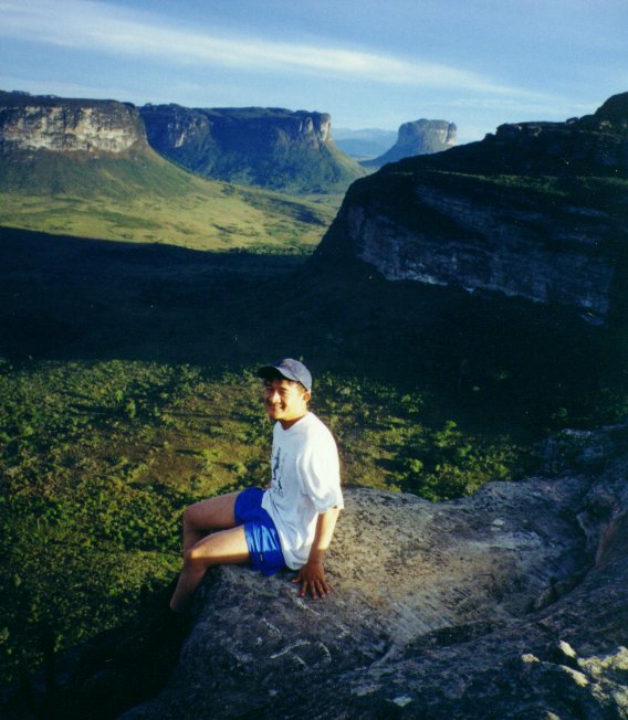
Our last destination was Morro do Pai Inácio (Father Ignatius' Butte), at 1120 metres (3675 feet) one
of the highest buttes in the Lençois area with a great view. This hill is the symbol of the Chapada Diamantina
region. The trailhead is guarded by a non-profit association from the nearby small town of Palmeiras, and a local
guide is mandatory. We were not charged an entrance fee because it is free for Brazilians. We followed our guide
hiking up at a pretty fast pace. It is a short hike over large granite blocks, surrounded by low, scrubby plants,
with an open view of the rolling terrain beneath. Soon we were on top, taking pictures. You can see many flat-topped
plateaus with vertical sides, like Monument Valley of Utah. However, everything is a soft green, the rolling lowlands
and the steep buttes. It is winter time in Brazil, warm and slightly humid in this part of the country because
it is only about 13 degrees south of the equator.
We returned to Lençois after this and wandered around, passing the time until our 11:30 pm bus back to
Salvador-da-Bahia.
Rio de Janeiro
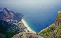
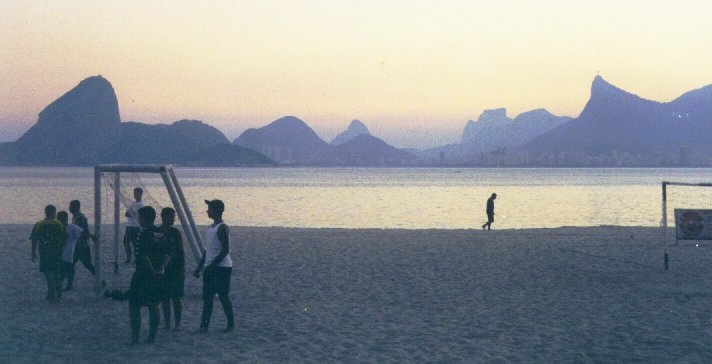
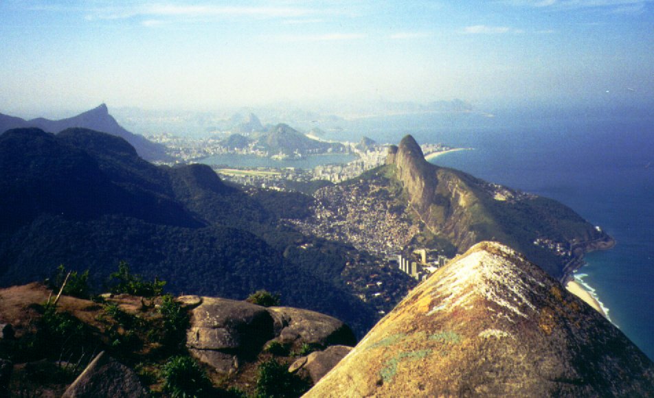
Rio de Janeiro's natural setting is the most stunningly beautiful I have ever seen. It occupies a promontory
separating Guanabara Bay from the Atlantic Ocean, its city neighborhoods cut off from each other by huge morros
(granite buttes) rising straight from the ground. There are many highway tunnels going through the morros of Rio
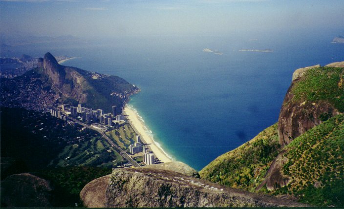
de Janeiro. In the southern part of the city there is a lagoon (Lagoa Rodrigo de Freitas) surrounded by many morros
on three sides and a strand of beach on its south side. This strand is the famous Ipanema beach on the east and
Leblon beach on the west. West of the lagoon and Leblon, the mountains rise much higher, forming coastal cliffs
and cutting off the southern from the northern parts of the city. This mountain area is the national park of
Tijuca.
Before going to Brazil my brazilian friend Cristina in San Francisco had referred me to the Montcamp
camping store for hiking and climbing guides. So I went to its downtown Rio location to find Rodrigo, who can book
me a climbing guide from Visão Vertical (Vertical Vision),
a guide company. I chose to climb Pedra da Gávea (Rock of Gavea), a more challenging climb than the
famous Sugar Loaf. It is also the highest morro in Rio de Janeiro with an elevation of 842 metres (2762 feet).
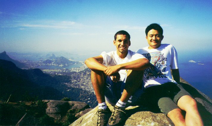
I would be meeting my guide, Márcio, at 8 am in the morning of July 11th, at Posto 12 (a life guard post)
in Leblon.
The next morning Márcio and I took a bus from Leblon towards the western hills, got off in a quiet neighborhood
beyond São Conrado. Then we walked for a block to the trailhead, which was gated with a guard station. We
started hiking steeply up, in a dense tropical forest without views. Along the way we encountered a few 20-30 feet
tall sloping granite slabs which had to be climbed with hands and feet. This forest used to be cleared in the 19th
century for coffee plantations, but had since been fully reforested with native tree species. The reforestation
was started by Brazil's second and last emperor, Dom Pedro II, who was a botanist. We encountered a few parties
of local young people on the trail. After about two hours of hiking, the forest started to open up, with great
views over nearby verdant hills and the beaches lining the blue ocean. The cool breezes tempered the heat of midday
sun. We were now at the foot of the granite monolith that is Pedra da Gávea, looking like a huge human face.
Here there is a section of relatively smooth sloping granite about 100 feet high, with a thin, inch-wide crack.
This is probably class 4 according to the rating system used back home. Some of the other parties already surmounted
it without using any gear. Márcio had asked me a while ago whether the granite slabs we passed earlier were
difficult or easy for me, I answered they were very easy. He went up first, pointing out the hand- and foot-holds
to me at each step. The holds were small but not difficult to hold on to. As I got higher up on the slope it was
a little scary if I looked down, but the slope was not too long or too steep to be frightening. Finally I successfully
negotiated this section. I was surprised to hear from Márcio that this was the most difficult section today.
I thought climbing the monolith above must be more challenging. He told me there is an easy trail that goes up
around the back side of the huge monolith.
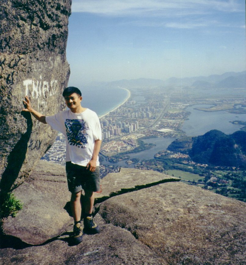
We traversed towards the back side of the monolith, enjoying a spectacular view of the beach far below us. Following
the trail first to a lower summit, then crossing an easy crevice to the higher one. Now we're on top of the flat
summit, although the true summit is the top of a large boulder about 5 feet higher. We explored all the rims of
the flat summit, sometimes descending to the ledges below, with dramatic exposure to the forested valleys or beaches.
Another hiker was also perched between rocks with a great overlook to the ocean. I took pictures in every direction,
especially east towards the famous landmarks of central Rio. On the west side, the huge Bay of Sepetiba lays out
below us, along whose shoreline are the new high rise suburban neighborhood of Barra da Tijuca, where there are
huge new shopping malls I just visited the previous night. Márcio and I rested in the sun on the summit
for more than 2 hours, enjoying the peace and quiet, the cool breezes, and the fabulous view. We had a laugh when
the topic turned to Vertical Limit, a recent movie about climbing K2 that is incredulous and silly, but
with spectacular avalanche and crevasse scenes. Later we decided to surmount the highest boulder whose sloping
surface converges to a cone, then perched on it for some time until another party approached.
The descent was fairly quick, but extremely hot in the early afternoon heat, even in the densely shaded forest.
When we got to the trailhead we had a glass of delicious and refreshing açaí (a tropical fruit of
Brazil) juice.
