 Cathedral Peak is possibly the most beautiful peak in Yosemite National Park, maybe even the whole of
Sierra Nevada Range. On September 20th, 2003, Vladimir Ulyashin and myself attempted this classic peak, and Vladimir
successfully made it to the airy summit.
Cathedral Peak is possibly the most beautiful peak in Yosemite National Park, maybe even the whole of
Sierra Nevada Range. On September 20th, 2003, Vladimir Ulyashin and myself attempted this classic peak, and Vladimir
successfully made it to the airy summit.
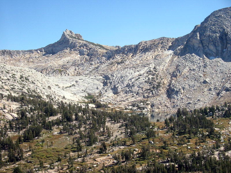
Cathedral Peak has a modest elevation of 10,911 feet/3326m. It is possibly the lowest Sierra peak I've attempted
in the last 3 years. However, Cathedral Peak is THE classic peak for people passionate about climbing, dating back when
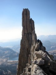
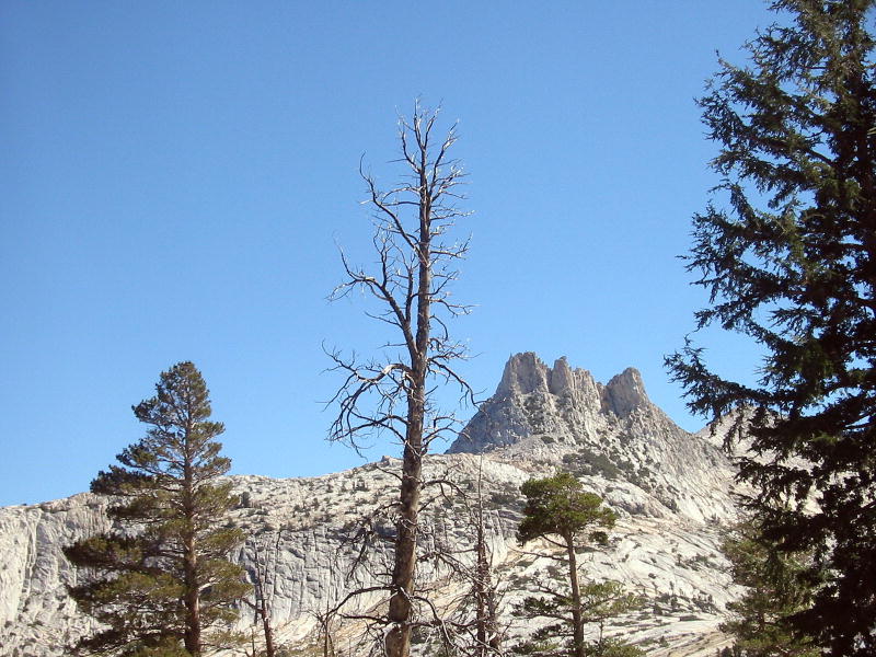
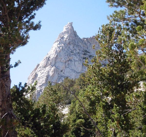
the famous John Muir first climbed it in 1869. Cathedral Peak is made up of two fantastic rock spires sculpted by ancient
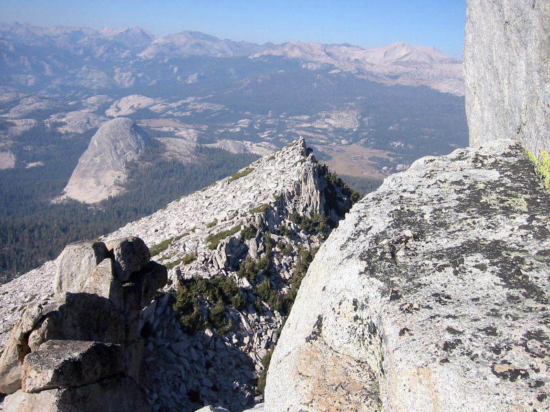
glaciers. The main summit is the eastern spire, the western one is called Eichorn
Pinnacle, both situated at the south end of the mountain. A rounded ridge extends north from the pinnacles, resembling
the elongated body of a cathedral. The entire mountain is made up of smoothly polished grey granite whose surreal soaring
curves seem straight out of a children's story book.
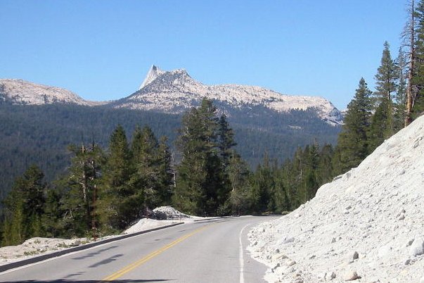
Cathedral Peak is located in the northern end of Cathedral Range, a western offshoot of the Sierra Nevada dividing the
Tuolumne and Merced drainages. The peak is only 3-4 miles from Tioga Pass Road, making for a very easy approach. The
trailhead is at the western end of Tuolumne Meadows. The most popular climbing route on Cathedral Peak is the Southeast
Buttress route, with a maximum difficulty of class 5.6, however, there is an easier class 4 route which ascends its northwest
side, nicknamed "Mountaineer's Route". This is our intended route, as neither of us have training in technical rock
climbing, nor do we have the ropes and other technical climbing gear. Since the total elevation gain is only 2300 feet, with
a one-way distance of 3 miles, we anticipated a leisurely day hike for Cathedral Peak.
On the evening of Friday September 19th, we drove through Yosemite National Park and camped at the lower Lee Vining Creek
campground. The next morning we slept in until about 10 am, then went to the Whoa Nellie Deli just down the road for
breakfast. This place was highly recommended by the folks on summitpost.com, and it was indeed a great establishment with
even oyster burger on the menu, and a nice store with everything a tourist would need. However I ordered a jambalaya which
was quite fatty, not the right type of food for hiking.
We made it to the trailhead around 11:30, which is a very late start. The route goes south on John Muir Trail, crosses
Budd Creek, then take an unsigned use trail on the left, which leads to Budd Lake. From the lake another use trail turns right
and ascends the north ridge of Cathedral Peak. We ended up unable to find Budd Creek, therefore missed the turnoff to Budd
Creek trail. When we almost passed Cathedral Peak's north flanks, we met a couple with a lot of climbing gear and a big dog
with them. They said they were going
to Cathedral Peak as well but found out they went too far on this trail. We tried to figure out our location using their
GPS loaded with topographical maps in its tiny display. It was pretty obvious we just went too far. We started backtracking while looking for a branch trail on the right. We found one but it petered out after
less than a hundred yards. We decided to go cross-country toward the direction (east) we thought the Budd Creek Trail
would be. The terrain was densely wooded but gently sloping, and sometime we had a glimpse of the triple-spired Unicorn,
a distinctively shaped peak east of Cathedral Peak. On the right we could see the rocky hump which is the
base of the north ridge of Cathedral Peak, but couldn't see where the summit pinnacles were. After going through
a lot of tree stumps and sometimes climbing easy granite slabs we were much closer to Unicorn, but our path still
hadn't intersected the Budd Creek Trail, nor could we determine where Budd Creek was, as there were some dry gullies
we weren't sure about. Afraid of getting too far east we decided
to abandon our attempts to find the trail, but instead just go south toward our destination. It was early afternoon
and it was very hot when not in the shade. We chugged along and eventually the forest became much sparser.
We caught a glimpse of the two soaring spires of Cathedral Peak. Later on there was a better vantage point,
where we could see about a dozen climbers on the near-vertical slope leading to the summit. We also heard many
voices. Then we started to see more and more footprints, which formed a use trail going right. We followed it up
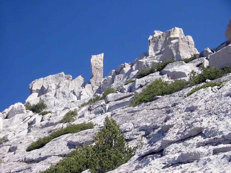
the slope through jumbled boulders and grassy patches. We were finally on the right track. Near the top of the
north ridge we got a great view of the southeast buttress where most of the technical climbers were. People were
moving slowly and formed a long line upward to the tip of the spire.
We climbed some class 3 rock to the top of the flat north ridge, which led to the summit on the left, through a
near-vertical rock wall. Met two un-equipped guys turning back from here, intimidated by this wall. Turned out
they're from Oakland. I informed them the easiest route does not climb the wall, but actually drops down on the
west side of north ridge to the base of Eichorn Pinnacle, then climb the west ridge to the summit. They turned
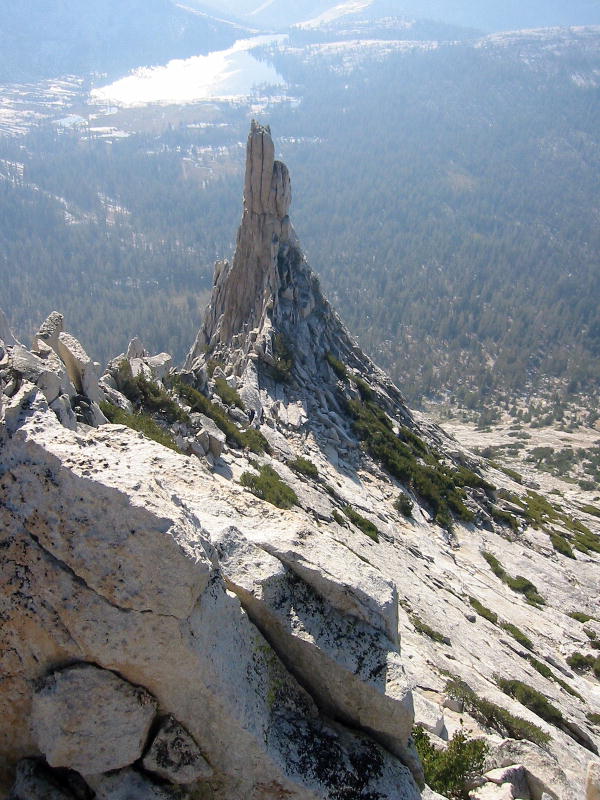
back anyway, although it was only about 3 pm. From this vantage point Eichorn Pinnacle looked rather puny, not
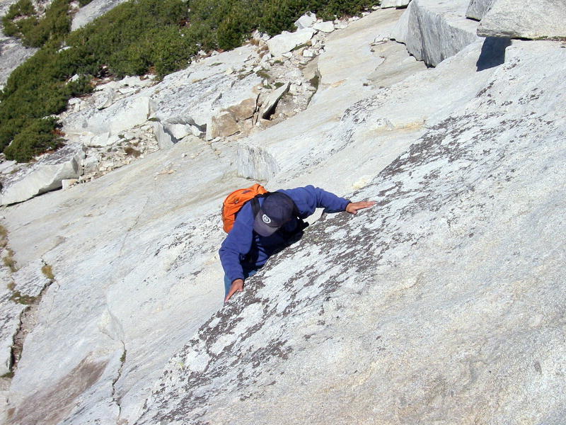
quite as imposing as I had seen in photos. However, the route traversing the northwest face of Cathedral Peak to
the west ridge looked intimidating. The northwest face is made up entirely of sloping rock slabs that curves to the
west, eventually dropping down to the Cathedral Lakes in one clean sweep. There were no ragged ledges, talus piles,
or rocky towers that I'm used to seeing on the higher mountains I've climbed. Presumably all irregularities
on the surface had been removed by ancient glaciers.
Crossing the center of the northwest face was frightening. Vlad had no problem, but I searched for hand holds
in the smooth slabs in vain. The sloping slabs were about 30-40 degrees, and I wasn't sure if there was enough friction
under my feet (I wore gym shoes with plastic soles). In the most difficult section I was able to move just
a few feet for a whole minute, making sure my center of gravity was low while trying to grab onto every little
irregularity in the rock. Finally I made it through and ascended to the base of Eichorn Pinnacle. However, I was
frightened by the prospect of going back through the same sloping slabs.
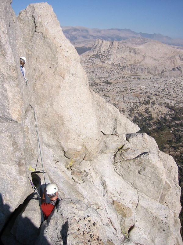
We saw several parties fully laden with gear coming down the summit. One father and son party recommended us
not to go to the summit, since we had no rope and bad shoes. I took the hint, and decided to wait there, as
Vlad would surely want to make the summit. Apparently, all the people we saw going to the summit had
ropes. I settled in a crevice between slabs, while Vlad went up the rocks following steep cracks. We talked via
our new two-way radio and soon I heard he was waiting right below the summit block. There were 3 roped parties ahead
of him. Before I hear him making the summit through the walkie-talkie, I fumbled with my camera which caused the
walkie-talkie unit to drop through the hollow bottom of my crevice, falling down many ledges. I went to look for it
but couldn't see it. After a while I saw Vlad on the summit waving at me. I shouted for him to come down, and
with a few tries he understood that I dropped the two-way radio so I couldn't communicate that way. Fortunately
the summit was in direct sight and only about 150 feet away so we didn't really need the two-way-radio.
Once Vlad came down we were able to locate and retrieve the dropped walkie-talkie by calling it repeatedly.
We decided to go down the west face, as I saw two elderly climbers descending it, and also had read a route
description on summitpost. I only brought a low-resolution topographical map and didn't bring the exact text of
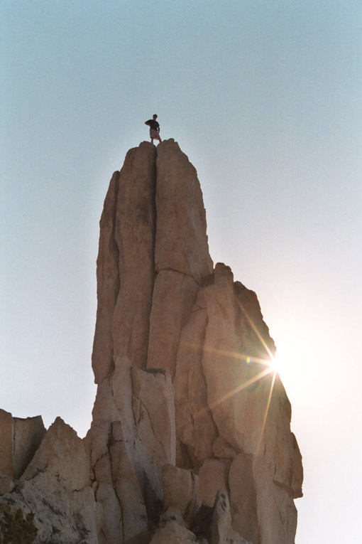
this route description, but I thought it would be easy to find the route. As this point a young solo climber
(without gear) crossed our paths and Vlad asked him whether he was going to climbing the Eichorn Pinnacle. He said yes,
and he proceeded to climb the extremely exposed rock on the north, then the west side of the pinnacle. I remember
it being class 5 so this is a very brave soul here. Vlad wanted us to go up too, but it was an absolutely
crazy idea to me. Free-soloing such an exposed route is extremely dangerous, and everyone we talked to said
that if you make one mistake, you die. Vlad still believed that he would be able to make no mistakes, but I
really don't need to deal with any kind of mishap. After the frightening traverse, my only desire was to go
back in one piece.
We descended lower down the northern base of spectacular Eichorn Pinnacle, and saw the lone climber making
it to the top. It was an incredible sight. Then he made it down safely as well.
Now to get to easier terrain we must traverse the same smooth rock
face I had so much trouble with. Fortunately lower down there was a much safer path we were able to use. Further
down the west face the terran became way too smooth and steep for me, I begain to balk. Vlad went through an exposed
ledge, then a ramp down leading to more 45 degree sloping slabs. It seemed way to difficult, and I proposed going
back the same way, which meant having to ascend a couple hundred vertical feet. We argued for a while, and
even though I was not down at his location, it was apparent there were no easy way down from his
vantage point. Vlad reluctantly backtracked, and we started ascending the slope, which turned out fairly easy,
as we hadn't descended too far. There was still a lot of daylight left so we were in no rush. We made it to the
top of north ridge without problems, and the rest was easy down the east side. In hindsight the correct
route down the west face of Cathedral Peak is supposed to start from the top of north ridge, traverse north further
then descend to the west. Our attempted route was completely wrong.
Going back down was straight forward, and there were a few other parties rushing down with us. We were
able to find the correct trail and follow it all the way to the branching point on John Muir Trail, passing a section
of trail high above Budd Creek. By this time the sky had turned fairly dark, but there was only a half mile
of distance left, so we made it quickly to the car. We never figured out where the John Muir Trail
supposedly crossed Budd Creek, or where we were when we couldn't find Budd Creek Trail. Some pictures from
this trip:
