 This was a backpacking and climbing expedition to Mount Lyell on 8/23-8/25 (Friday to Sunday),
2002. Mount Lyell has an elevation of 13114 feet, or 3997 metres. It is the highest mountain in Yosemite
National Park, located on the apex of the Yosemite mountain system. From the summit of Mount Lyell
radiates five giant ranges that divide the sources of Tuolumne River, Merced River, North and Middle
Fork San Joaquin Rivers, and Mono Lake. Mount Lyell's glacier is the second largest in the Sierra Nevada
mountains. My partner Vladimir Ulyashin succeeded in summitting Mount Lyell on August 24th, while I made it
to within 200 vertical feet of the summit. This was the most challenging climb I've ever had so far, from the rock
climbing difficulty to the arduous approach (13.3 miles hike one-way), but the astounding beauty of the region
makes me want to come back soon.
This was a backpacking and climbing expedition to Mount Lyell on 8/23-8/25 (Friday to Sunday),
2002. Mount Lyell has an elevation of 13114 feet, or 3997 metres. It is the highest mountain in Yosemite
National Park, located on the apex of the Yosemite mountain system. From the summit of Mount Lyell
radiates five giant ranges that divide the sources of Tuolumne River, Merced River, North and Middle
Fork San Joaquin Rivers, and Mono Lake. Mount Lyell's glacier is the second largest in the Sierra Nevada
mountains. My partner Vladimir Ulyashin succeeded in summitting Mount Lyell on August 24th, while I made it
to within 200 vertical feet of the summit. This was the most challenging climb I've ever had so far, from the rock
climbing difficulty to the arduous approach (13.3 miles hike one-way), but the astounding beauty of the region
makes me want to come back soon.
The standard approach is to follow Tuolumne River from Tuolumne Meadows in Yosemite Park
to its source, the Lyell Glacier, for a one-way distance of 13 miles. Instead, we decided to take the
Rush Creek approach from the east. Rush Creek is the largest source of water of Mono Lake.
Although this route is documented in RJ Secor's guidebook in a few lines, I couldn't find any other
detailed information about it. Therefore, above Lower Marie Lake where the trail ends, our planned
route is basically a rough sketch on the topographic map based on contour lines, as neither of
us had ever been in the area. My interest in taking the Rush Creek route rather than the standard
route is threefold: 1. to avoid ascending Lyell Glacier, which may be icy in late summer and require
the use of crampons; 2. to explore an area full of large lakes instead
of the mostly lakeless Tuolumne River canyon; 3. to possibly ascend Rodgers Peak, the third
highest peak in the area after Ritter and Lyell. Although Secor rated the east side route to Lyell
as class 4, which is beyond my ability, I was convinced from my reading of the map that there is an
easier alternative.
The 13.3 mile each-way approach is longer than we have ever done before, so we decided to drive to the
mountains on Thursday night. We ended up passing through Yosemite Park and reaching Tioga Pass at
about 1:30 am on Friday morning. We camped at the Tioga Lake campground immediately east of the pass,
at elevation 9673 feet. This would be a good way to get acclimatized to high altitude. When we arrived
at the campground the sign said its full, but we still found a spot. Later we found out that our spots original
occupants left in the middle of the night because they were not used to the coldness. We got up around 7
am in a glorious highland morning. Tioga Lake is a beauty set at the foot of 13053-foot high Mount Dana
surrounded by high meadows. The next thing, I was locked inside the restroom at the campground for
about 15 minutes. The lock was stuck, and I started banging the door. With some help from the camp
manager and Vlad, we managed to free myself.
In the morning we ate breakfast at Lee Vining, got wilderness permits and rented a bear canister from
the Mono Lake Visitor Center. The visitor center's setting at the shores of the vast salt lake is spectacular,
and we strolled around it while waiting for its 9 am opening. Then, after getting some groceries we headed to the
trailhead, next to the pretty Silver Lake resort at elevation 7200 feet. There was an old man
stationed at a kiosk there, who came around to check the permits. After a little packing, we hit the
trail at 11:15 am.
The trail starts with a grueling climb up the granite cliffs in hot mid-day sun, through many switchbacks
which brought us to Agnew Lake, a small reservoir. There is an old tramway both below and above this lake,
probably built long ago for dam contruction upstream. Further up we reached Gem Lake, a large, blue, dammed lake
surrounded by steep hills. The trail became like a roller-coaster, with many 50-200 feet downhill sections,
then climbing more to make up the elevation loss. We saw obvious signs that the dusty trail is well-used by
horse packers. With more ups and downs through
rocky hillsides, meadows, wooded stream banks, we reached the next one - large, dammed Waugh Lake. We re-filled
drinking water here, now it is late afternoon and my legs were very tired. We were hoping to reach
Lower Marie Lake for the night, it didnt seem possible now. We proceeded past the lake into riparian forest
along cascading Rush Creek, by this time the sky had darkened, and no moon was in sight. In the woods we
started to get lost, so we decided not to go any further. We selected a camp site right next to the trail junction
between Rush Creek Trail and Pacific Crest Trail (elevation approximately 9700 feet), around 9 pm. Although
nominally the days total elevation gain was only 2500 feet, due to the ups and downs along the trail it was
at least 30% more, so the total was more like 3200 feet, on which we spent almost 10 hours hiking.
The next morning we got up around 7 am again, decided to pack up and move camp higher up. We left
camp at about 7:30, taking our backpacks and walking in the morning light. We reached a high open spot
with great views of the Ritter Range (Banner, Ritter, Davis, Rodgers), then a series of beautiful ponds reflecting
the surrounding mountain crest. Another 700 foot climb and well be at Lower Marie Lake, elevation 10850 feet.
Along the way we lost the trail, so we just climbed the gentle granite slabs. In a while we regained the trail,
and followed it all the way to Lower Marie Lake. The lake was large and flat, with several peninsulas and islands.
There were quite a few good camp spots, and we set up camp there around 10:15 am. I packed a light day-pack
with lunch, camera, and a coat. After resting for too long, we started toward Mount Lyell at 12:25 pm.
First we traverse the left side of the lake then curve to the right, ascending a steep slope on the southwest
side of the basin. There is a waterfall coming from Middle Marie Lake, not far to the right of us. We chose to
ascend along a bunch of grassy spots in order to avoid long sloping granite slabs to the left. Soon we ascended
above Middle Marie Lake (11228 feet), another large lake but surrounded by steep talus slopes and glaciers.
Below us there were several long snow slopes that drop into the lake. I opted to traverse higher where its not
as steep, Vlad decided to traverse lower to avoid elevation loss later. In a while I lost him already. I started
shouting and even blowing the whistle. I saw a pretty much impassable cliff below me, then a steep glacier
dropping into the lake. It was terrifying. Fortunately he was way above me already, after traversing the rocks
next to the glacier.
We reached the bench above Middle Marie Lake, traversing abvoe a glacier. There lies smaller Upper
Marie Lake (elevation 11746 feet), in the north cirque of massive Rodgers Peak. We cross the outlet of the lake,
but started debating the next step. My plan was to ascend the peaklet (12560 feet) west of the lake, then traverse
the Rodgers-Lyell ridge northward to Lyell. Vlad thinks its easier to traverse the glacier on the right of the peaklet.
After some discussion and map reading I decided to go with his idea. It turned out my route had about 200 feet
of extra elevation gain, and potentially was more difficult and time-consuming. Being determined to avoid walking
on glaciers, I convinced him to traverse on rock right above it. It was somewhat difficult rock climbing, about class
3, but we were glad when we finally passed it. Beyond it there was a nice low-angle moraine slope leading all the
way to Lyell-Rodgers Ridge! Its a god-send. By this time I had no illusions about climbing either Rodgers Peak
or Maclure, because we were running very late and Lyell doesnt seem easy to reach.
We followed the easy moraine up toward the ridge. It was very nice walking, although
I was breathing hard and resting often, due to the high altitude and my not being in great shape. We reached the
ridge at 12460 feet level at a fair flattish spot. Toward Lyell however, we immediately were faced with a knife edge,
sometimes narrowed to 2 feet wide, sloping on top, with several hundred feet vertical drop-offs on either side. I was
a little scared, Vlad was not at all. The knife edge continued on and on, and I was slower and slower to traverse it,
especially after a bit of impatience caused me to have a near miss and bruised my right shin. You can never be
too careful in this place. Vlad was already reaching the point where the left side became a moderate talus slope.
We got off the ridge to traverse the talus to the col east of Lyells summit. Vlad called to me and told me its very
beautiful at the col.
At the col there was a spellbinding view of Lyell Glacier. Instead of being far below as we expected, the glacier
bulges to nearly as high as we were, and its surface is fairly flat closer to the mountain. Toward Mount Lyells
summit on the left there was about 300 more vertical feet of steep rock, where Vlad already climbed up a lot. The
sun was about to set, sending soft orangish glows to the rugged peaks surrounding us, making a pretty golden
wave pattern on the sun-cupped surface of the glacier. I was mesmerized by the glorious beauty as I looked around
to count the number of new peaks Ive never seen before, to south guarding the Merced basin, to northwest dividing
the Tuolumne basin, and the more familiar ones to the northeast (Dana, Kuna, Koip) and southeast (Ritter Range).
On the other hand, I was near the end of my strength, it being almost dark I had not much faith of summiting Mount
Lyell, only a little ways further. Under Vlads prodding I continued to climb up toward the west, but the section was
dramatically more difficult. Being a knife edge at a steep gradient, I searched patiently for an easier route,
sometimes dropping down to the glacier on the right. There was a small opening of the glacier, a crevasse of sorts
(called a bergschrund) near where it touches the mountain. Underneath one can see icicles hanging down into the
dark abyss. I came back up to the top of a small pinnacle, but could not advance further as there was a deep gap
between it and the next, higher one. I finally called it quits, just waiting there for Vlad to come back. It was getting
pretty chilly and I tried to call Vlad several times. I decided to slowly retreat since it was getting dark and cold.
In about half an hour I saw Vlad again at the col. He told me up near the summit the climbing was exceedingly
difficult, maybe class 4 or 5, one had to climb down each smooth vertical pinnacle before going up the next one,
like this all the way to the summit.
The descent was an ordeal, as it was already dark and cold, we were beyond total exhaustion, but had no choice
but to slowly and patiently negotiate each dangerous section. Traversing Lyell-Rodgers Ridge took quite a while, but
I remembered the holds I used to climb up, so there were no problems. After a while the full moon had risen, the
visibility was so much better. Descending the class 3 section above the glacier was more difficult for me, as it was
in the shadow of the moon light, and I already forgot how I came up. I got myself into some hair-raising sections and
had to retreat, although Vlad had no problems. After that it was fairly easy, just had to drag my legs to the next rock,
then the next. Below Upper Marie Lake I decided to take the right side slope to descend directly to Lower Marie Lake,
skirting the steep glacier on the left. It turned out much easier for Vlad, while I had a little trouble with the steep sloping
slabs which we got ourselves onto. Probably took me an hour to descend that 1000 vertical feet slope. Vlad
was patiently waiting below, then we joined and finally made it to camp at 12:50 am. It took us 12 and half hours to
climb Mount Lyell, and our day was 17 hours, 40 minutes long! I had never done anything so arduous before. We were
so glad to be eating some hot food and lying down. Sleep came immediately, just like the previous night.
The next day we packed up the camp and started walking at 10 am. Although we were descending on trail, it was about
11 miles long from Lower Marie Lake to the trailhead, several miles longer than our first day. Around Gem Lake where
the trail went up and down like crazy, I cursed the people who built it. After that it was all the way downhill and we were
finally at the trailhead by 4:50 pm. We had hiked for about 7 hours. We sped back after returning the bear canister and
eating most of a big watermelon at Lee Vining. When we passed through Yosemite Park the ranger told us it was free
of charge because it was the anniversary of the parks founding.
This was truly an epic trip, and the vast, majestic high country we explored was worth all the sweat and aches.
Some pictures from the trip:
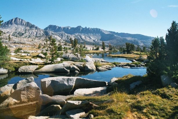
- Morning view of Ritter Range, with Mount Davis in center right, Banner Peak
is the sharp one on the left.
- The ponds of Rush Creek in the morning, Koip Crest pinnacles in the background.
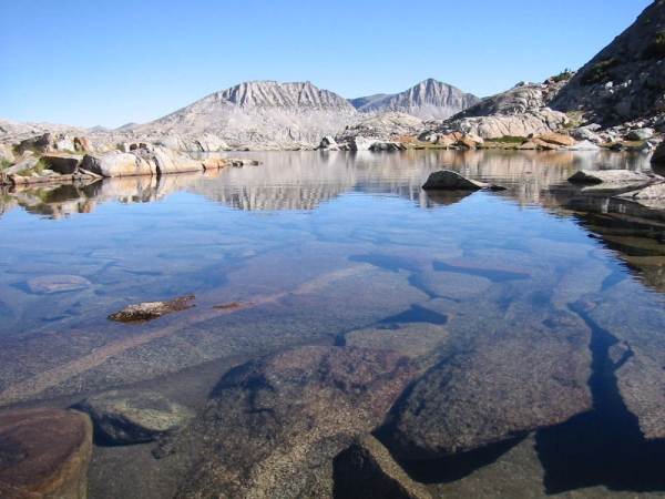
- Lower Marie Lake, looking toward Donohue Peak.
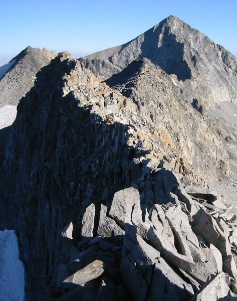
- Me at the beginning of the Lyell-Rodgers Ridge traverse, Rodgers
Peak is behind, and Merced basin is on the right.
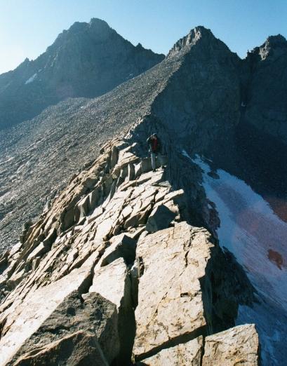
- Me (little speck in the center) traversing the knife edge of Lyell-Rodgers Ridge,
Rodgers Peak is directly behind.
- Vlad on the knife edge of Lyell-Rodgers Ridge, Mount Lyell's summit is on the
left behind him.
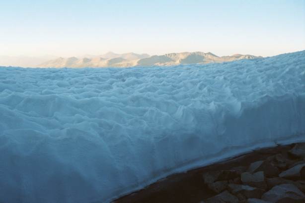
- Close-up view of Lyell Glacier, below the massive ice sheet is a hollow, dark abyss!
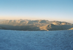
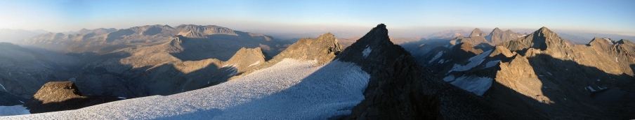
- Panorama from the summit of Mount Lyell (north, east, and south): East Ridge of
Lyell in the center;
on the left in the foreground is Lyell Glacier, in the distance are Tuolumne River basin, Kuna Crest, Mount Dana and Koip Crest;
on the right in the foreground is Rodgers Peak, behind it to the left are Banner Peak and Mount Ritter, far right is Merced River
basin and Electra Peak.
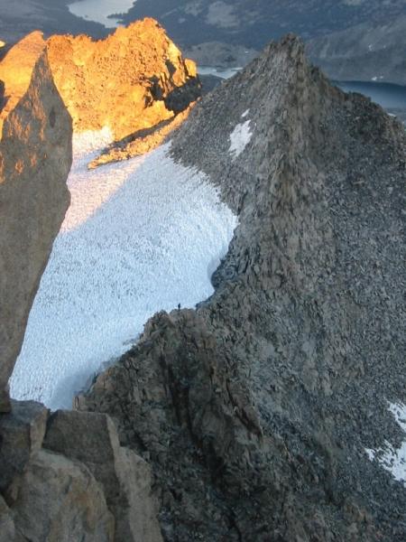
- Me (little speck in the center) on the east ridge of Mount Lyell. Vlad took this picture from the
summit.
