 This was a backpacking and climbing trip to Matterhorn Peak in California's eastern High Sierra on September
23-24, 2000. Matterhorn Peak (12,279' / 3743 m.) dominates the Sierra Nevada crestline in the northern Yosemite
area. It has an impressive horn-like appearance with four knife-edged ridges radiating from it, resembling the
better-known Matterhorn Peak in the Swiss Alps. Matterhorn Peak was celebrated by Jack Kerouac's novel Dharma
Bums. Vladimir Ulyashin and I succeeded in summitting the Matterhorn on September 24th, following the easy (class
2) route through Horse Creek Pass and the southeast slope of Matterhorn.
This was a backpacking and climbing trip to Matterhorn Peak in California's eastern High Sierra on September
23-24, 2000. Matterhorn Peak (12,279' / 3743 m.) dominates the Sierra Nevada crestline in the northern Yosemite
area. It has an impressive horn-like appearance with four knife-edged ridges radiating from it, resembling the
better-known Matterhorn Peak in the Swiss Alps. Matterhorn Peak was celebrated by Jack Kerouac's novel Dharma
Bums. Vladimir Ulyashin and I succeeded in summitting the Matterhorn on September 24th, following the easy (class
2) route through Horse Creek Pass and the southeast slope of Matterhorn.
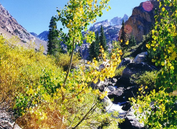
Around noon of September 23rd we started backpacking from the Twin Lakes trailhead (7200') near Bridgeport,
CA up Horse Creek drainage. The brilliant golden colors of fall was starting to show in the valley, although not
in full force yet. Horse Creek was still full of water pouring over thunderous falls and cascades. From the beginning
one can gaze up at the whitish, jagged, high granite walls of the Sawtooth Ridge, the thin pinnacles on top of
the ridges, and of course the sharp-pointed "horn" of Matterhorn. The official trail turns into a use
trail after passing the first group of meadows. Soon after route finding became troublesome, as there were many
use trails criss-crossing the valley, so that we had to make corrections to our route several times. After passing
the second and third meadows, we finally set up camp at the last little flat spot (~~9700') before Horse Creek Pass.
This way we were able to put away half of the hefty 5000'+ elevation gain necessary to reach the Matterhorn.
The next morning we left camp soon after sunrise, heading up the huge talus piles at the head of Horse Creek
valley. We crossed the crestline at a reasonably flat spot (~~10,860') about 200' higher than Horse Creek Pass,
which looked more difficult to cross due to steep snow fields. At the crestline one has a wonderful view of the
south side of the pass, gazing down the gentle meadows in Spiller Canyon and further to the vast forests around
Tuolumne Meadows in Yosemite National Park Dozens of distant peaks in southern Yosemite and beyond were visible
from here.
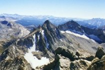
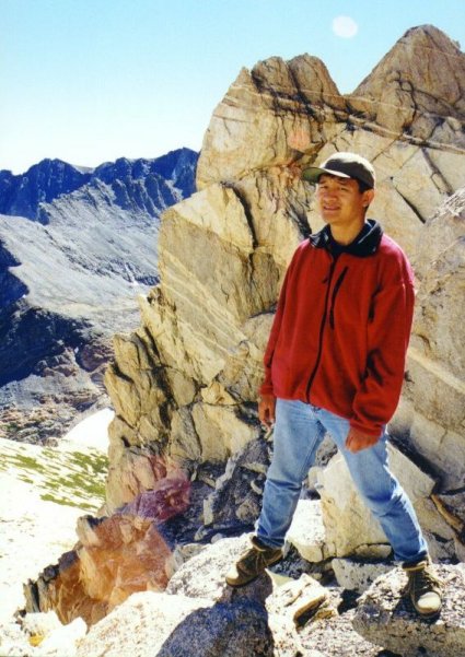
From there the route to the summit of Matterhorn traverses a reasonable gradient of grassy knolls, slabs, and
sandy slopes, until the base of the summit block, where there were several big rocky towers. We passed between
two of these, climbing slabs to a small saddle (~~12,080') which is the top of the East Gully. There was a 6 ft
tall pinnacle resembling a shark tooth. From the gully one sees a glacier about 1000' below, as well as the sheer
granite face leading up to the summit. From there we climbed the steep east wall of the summit block, diagonally
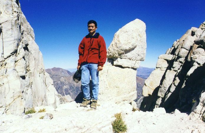
towards south for easier climbing. The rock was solid with plenty of holds, it was quite fun to climb. Soon we
made it to the ridge, and a few steps further we gained the 12,279' summit of Matterhorn, after climbing for about
5 hours 10 minutes. The summit is a small place hardly enough for five people to stand on, with sheer drop-offs
on north and east sides to the glacier below.
We planned to head out the same day, so we had to hurry back down to camp, picking up the stuff, then head down
to trailhead. The hefty 5000'+ elevation drop was quite tiresome, and took us longer than expected. We were walking
long after sunset with our flashlights for the last 2 miles.
Here are some pictures from the trip:
- Fall color in Horse Creek valley, Matterhorn is in the background.
- Wild berries in Horse Creek valley
- Camp site beneath Horse Creek Peak
- At the second meadow in Horse Creek valley (this photo was taken after
sunset)
- By a rocky tower on the steep southeast slope of Matterhorn
- At the top of East Gully next to the shark-tooth pinnacle.
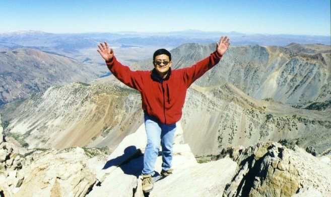
- Me reaching the summit of Matterhorn
- Southern view from the summit of Matterhorn: Whorl Mountain, Virginia Peak,
Mt. Dana, Mt. Conness, Mt. Lyell, Mt. Ritter, Mt. Florence, Mt. Clark, Mt. Hoffman, etc.
