 This was a day hiking trip to the top of University Peak in Kings Canyon National Park on Labor Day
weekend, August 31, 2003. Vladimir Ulyashin and myself successfully reached the top of this gigantic mountain after
overcoming nearly 5000 feet of elevation gain in one day, creating a new record for both of us.
This was a day hiking trip to the top of University Peak in Kings Canyon National Park on Labor Day
weekend, August 31, 2003. Vladimir Ulyashin and myself successfully reached the top of this gigantic mountain after
overcoming nearly 5000 feet of elevation gain in one day, creating a new record for both of us.
University Peak has an elevation of 13,632 feet/4155m, it is the first high peak over 13,500 feet south of the
Palisade group. It is on the crest of Sierra Nevada mountains on the eastern border of Kings Canyon National Park.
University Peak was named after University of California (Berkeley) in the late 19th century. I planned this day hike
to University Peak because of its close proximity to the Onion Valley trailhead, only a little over 4 horizontal miles from
trailhead to the summit via the class 3 North Face route. Because this was a holiday weekend we anticipated that
backcountry camping permits will be in short supply for popular trailheads, so it makes sense to do day hiking
instead, eliminating the extra time needed to haul heavy loads and to wait in line for a permit. I calculated the
net elevation gain will be about 4700 feet, which was unprecedented for either of us for a single day. However, we
were up for the challenge. University Peak has a whole range of easy to difficult climbing routes. The North Face route
although is not the easiest, but it is the most feasible for a day hike because it follows a direct line to the
summit from Kearsarge Pass Trail.
Learning from mistakes we made in our two earlier trips this year to the Palisades, we planned the logistics much
more carefully. We would spend two nights and one day acclimatizing to the high altitude. The first night (Friday 8/29)
we slept at a campground along Lee Vining Creek (elevation was about 7000 feet) just east of Yosemite National Park
and didn't get up until about 10 am next morning. Then we drove all the way down to the Onion Valley trailhead near Independence, CA to
reserve a camp site at the Onion Valley campground. Fortunately, by the time we arrived there (about 1 pm) there were
still two sites left. Sleeping here the night before our big hike is a great advantage because there will be no time
wasted driving to the trailhead in the morning, and the high elevation (8900 feet) would be good for acclimatization.
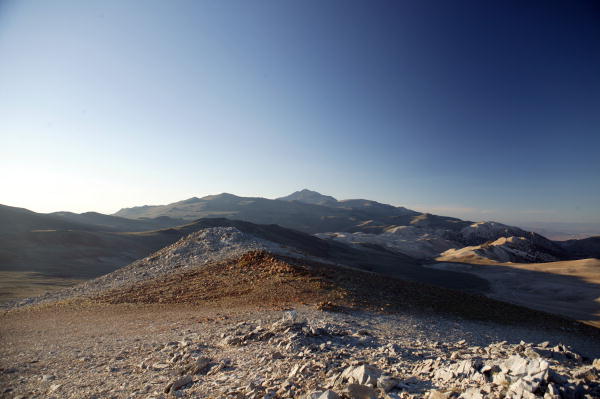
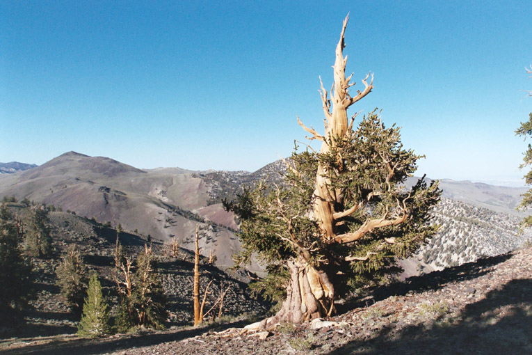
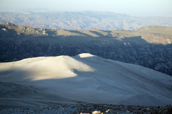
After securing a camp site at Onion Valley we drove up White Mountains, where we reached about 11,500 feet elevation.
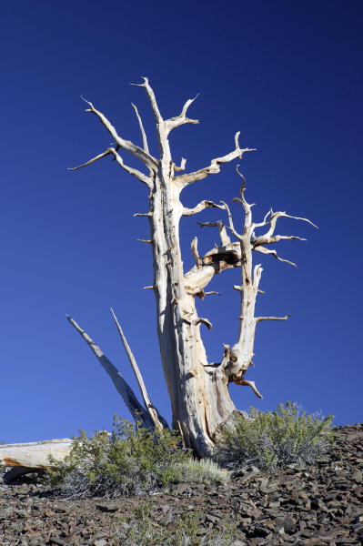
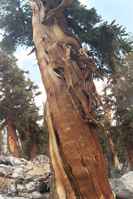
Besides photographing the wonderful Bristlecone Pines (over 4600 years old, the oldest living things on earth),
taking in the majestic views of the eastern Sierra Nevada crest, we also did a small hike to one of the totally barren,
white limestone covered peaklets near the road. Although the White Mountains have very harsh environments (dry and cold
year-round), it is one of the most serene and beautiful places I have ever been, it reminds me of Tibet at times.
The beauty of the barren white dolomitic rocks combined with layer after layer of gently rolling ranges on the horizon
gives one an understated but surreal impression.
Coming down from the twisting dirt roads on White Mountains took a long time. We descended into a grocery store
in Big Pine to stock up for dinner and breakfast. I bought cans of meat and vegetable soup plus several sandwiches
intending to bring on my hike the next day. The abundant food proved just what I needed to keep my energy level up
on the mammoth hike to University Peak. We finally reached camp at Onion Valley trailhead around midnight, then
immediately went to bed.
On Sunday morning (8/31) we woke up at 6:30 am as planned, then after getting ready we started hiking at 8 am. This
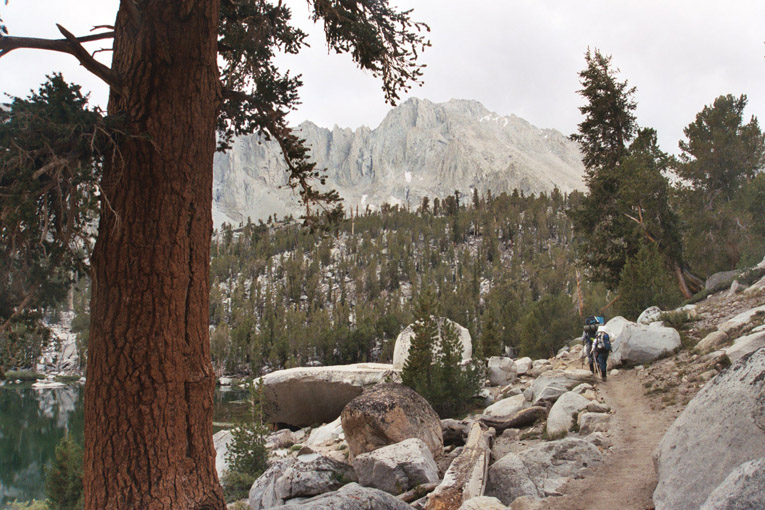
is one of the earliest starting times we've had lately, and it proved to be just adequate for this hike. We followed
Kearsarge Pass trail for about 2 miles until a point between Gilbert Lake and Flower Lake, according to directions I
obtained from summitpost.com, an online climbing site. From there we took an unsigned trail branch on the left toward
Matlock Lake. The weather was very gloomy from the beginning, with dramatic dark clouds covering the entire sky, and
cold breezes cast a chill on our climbing ambitions. Vlad was very upbeat always; he noticed that the clouds were rapidly
moving from south to north, and predicted that the weather will clear up soon. It turned out parts of the Sierra further
north were pummeled with thunder, lightning and hailstorms that day, fortunately the wrath of the thunderclouds escaped
us entirely. We met a Russian-speaking father-and-son party of backpackers also attempting to climb University Peak,
however, the father was very worried about the weather. Later on he told us they would go to Kearsarge Pass and call
it a day instead.
The lakes we passed along the Kearsarge Pass Trail were quite uninteresting compared to what we saw in the Bishop
Pass area. Most lakes were walled-in by high rocky slopes or cliffs, plus the gloomy weather gave them dull colors. Within
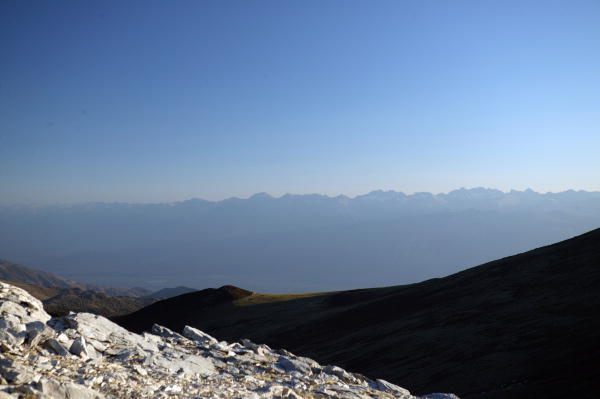
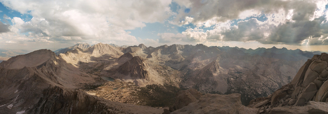
a short time of hiking from the trailhead we already saw University Peak, very high and imposing with several greyish
cliff faces on its northeast side. We could also clearly see the rib in the middle of its sloping north face; we would be
following this rib all the way to the top. Near the end of the branch trail to Matlock Lake, the trail started to descend. We got off the trail and climbed a small
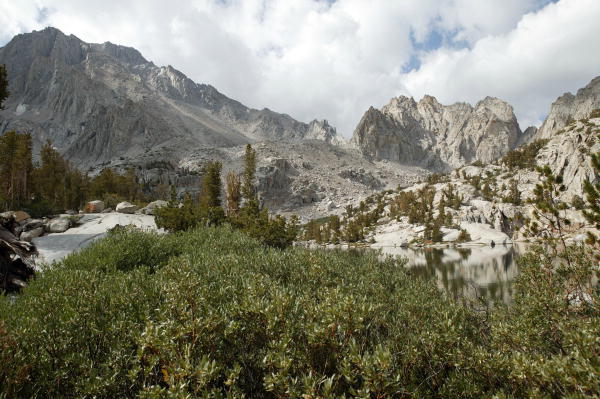
forested slope to the top of a small ridge west of Matlock Lake. Now we see another fairly large lake on the west side;
this is Bench Lake. We follow the ridge southward between the two lakes, climbing up and down sloping slabs until we reached
a small depression at the foot of University Peak proper. There is a small tarn west of us (Lake 3460m), which is right
below the north face of the peak.
The weather seemed to be getting better, sometimes revealing large patches of blue sky between the clouds, and sometimes
even some sunshine. I started to get warmer and much more confident. We took a break and I ate half of a sub sandwich I
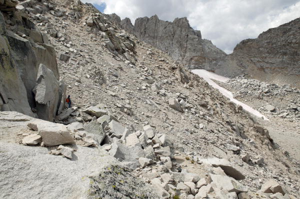
bought the previous night. We resumed climbing around 11:50 am. Immediately we're face with lots of loose scree. Vlad
decided to climb on the east edge of the north face, where there are some slabs. I climbed a direct line across the first
scree chute aiming for the north face rib. We were able to see each other across the chute, as I heard Vlad triggering
large rock falls while fighting with piles of rubble myself. After about 20 minutes I was on firmer ground on the rib. Vlad
crossed over to the rib as well after avoiding the loosest part of the chute. We resumed climbing up and up, mostly on
decent class 2 rock and occasionally loose stuff. The slope is almost 3000 vertical feet, much larger than Mount Agassiz's
2000 feet, but looked smaller because the slope was lower-angle so we did not see the true top of the route. Higher up the
rib we soon realized the all the surrounding peaklets that looked comparable to University Peak before are totally dwarfed
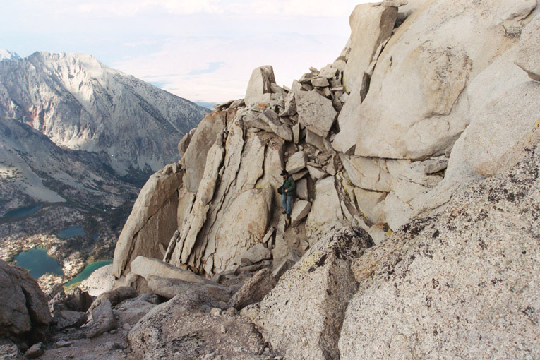
now. The rib sometimes were choked by car-sized talus which required class 3 climbing. Even higher we reached a rock tower
which defined the end of the rib. Now we saw there were still maybe 600 vertical feet more to go to the summit ridge along
a fairly loose slope bounded by near-vertical cliffs on either sides. We saw the start of some dramatically steep chutes
here, and debated whether they would make good descent routes. We later decided against taking any of them, and in hindsight
it was absolutely correct. Several of these chutes turned out to end on the northeast face of the mountain where the terrain
is class 4-5.
Vlad was suffering from stomach upsets, and I felt good because of the improving weather and the hearty lunch, so I
charged ahead. It would get hot at one instant when the sun is out, and get cold next instant when the clouds cover it. I
kept switching between my baseball cap and my ski mask. The strategy worked fine. I made it to the summit ridge, then was
immediately blocked by a huge monolithic peaklet on the west side. The south side of the ridge was a vertical cliff
dropping thousands of feet. Vlad helped me figure out how to circumvent the peaklet by passing through a "window" of rock on the
north side. This was the most exposed point on the route. Next I followed fairly exposed ledges until reaching the base
of the summit. At 5 pm I surmounted the summit after going around the huge block and finding a steep crack on the south
side of it. The summit was exposed on all sides except for this crack. I was relieved the find the summit register since
there was another peak of almost equal height just to the west of me across a deep gap.
Vlad made it to the summit shortly after. I found someone left an opened-roll of "lifesaver" candies in the metal can
housing the register books. There were only three pieces left, and it looked pretty fresh. I ate one but Vlad refused even
though he was craving for sweets. We were both incredibly exhausted, after overcoming the most elevation gain we've ever
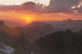
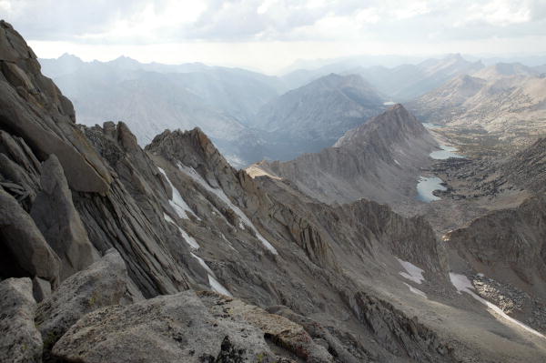
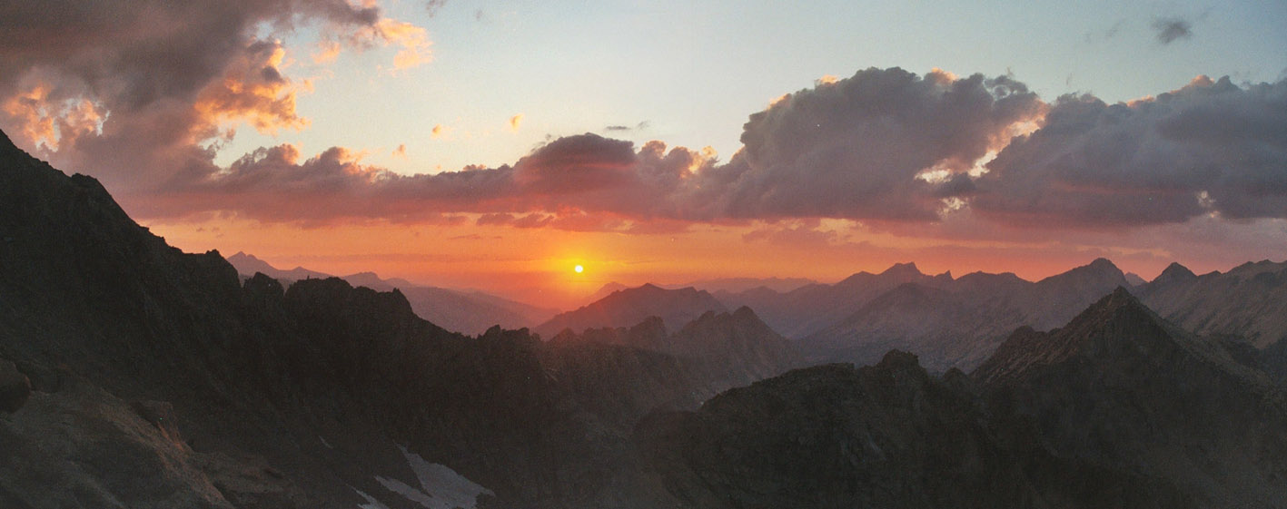
done in a day. We descended after spending about 40-50 minutes on the summit. Needless to say the views were incredible
especially with the dramatic clouds on the sky; it was also my first time gazing upon many of these mountains.
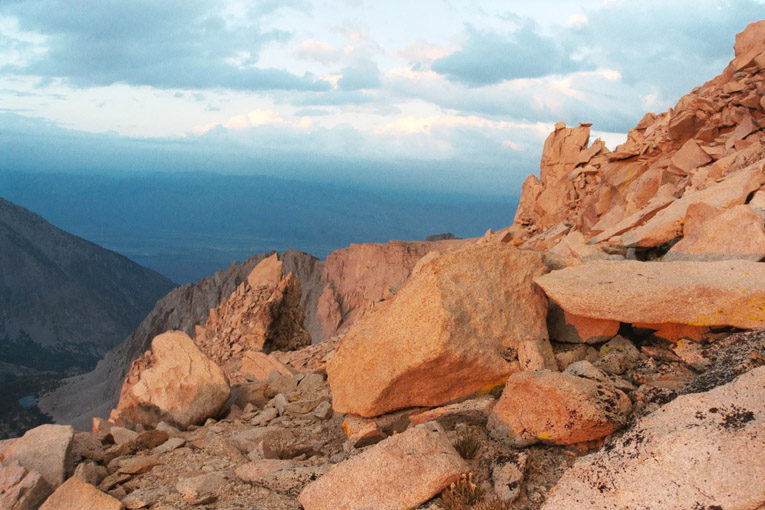
I hurried down on the same route while Vlad was feeling ill and moving much slower. About 2/3
of the way down the sun sets, casting dramatic warm glows on the granite, making them look pinkish. After taking some
pictures I lead the way down the loose chute, trying to slide down the mountain as quickly as possible. I would hate to
have to negotiate talus in the dark. Vlad didn't like the scree descent, he preferred talus. The moon shone for just a
few minutes before it too sets. The last few hundred feet of the north face of University Peak were descended in semi-
darkness, until we reached Lake 3460m.
From the lake I decide to follow a direct line to descend to Matlock Lake, instead of following the ridge around it as
we did during the ascent. It was such a big mistake, because this route was completely uncharted and I didn't realize
it was in fact steeper. We turned on our headlamps and started to descend towards Matlock Lake, but could not even see
where the lake was. We descended some sloping slab, then more and more of it, many ending up in 20+ feet high overhanging
cliffs. Some parts were so steep we could not see the bottom with the limited light. At one point we had to backtrack up the
slab to find an alternative way down. It was so frustrating. Another time I descended a slab and found out I could not
stand still because of the steepness, so I had to run across the steep chute. Fortunately we did not encounter too much
soggy ground, although we did cross some wet slabs. Eventually we got down to the lake level, but its shores were choked
by thickets. I lost my calm and started to feel desperate. Vlad suggested that there was probably a use trail around the lake,
so he was confident we could get to the other end of the lake. We walked toward the right direction while keeping it high
and dry; miraculously footprints started to appear. With Vlad's encouragement I was able to find a faint trail, which
sometimes disappears and reappears. I kept going in the right direction and soon the trail became more apparent. Following
it for maybe 10 minutes we were able to see the many lighted tents that we saw earlier on the way up. We remembered this
place was where the trail descended. Bravo!
Following trail it became so easy. It took us another hour and a half to walk down to the trailhead, with both of us
in total exhaustion. Near the end my headlamp turned off because of spent battery, but we made it back without much trouble.
The short approach to University Peak was really a life-saver. This was the first time I attained the summit of a high peak
in about two years, so I'm really proud of it.
Sightseeing White Mountains
Climbing University Peak
